November 2021

An introduction to the Shambles, Chesterfield

There’s a brief introduction to the Shambles area of Chesterfield in this blog. We also dispel the incorrect theory, often repeated, that the area was originally temporary market stalls which became permanent structures over a period of time.

Revitalised – part of the Shambles pictured in 1984, looking up towards High Street. (Chris Hollis)

There’s no evidence – as our ‘Chesterfield Streets and Houses’ book states – that the Shambles were originally market trader’s stalls that became permanent buildings over a period of time. It’s worth quoting from our book to give a short introduction to the area.

When the New Market was laid out in the late 12th
century, an area at the eastern end of the Market Place
was reserved for a large block of shambles, intended
for butchers, fishmongers and possibly other traders
who would have stood in the market every day, not
merely on Saturdays. The block was bounded on the
east by what is now Packers Row (which appears to
have marked the western limit of the built-up area
before the New Market was created), on the south by
what is now Central Pavement (named by Potter in
1803 as Toll Nook, presumably referring to a place
where tolls were collected at the eastern entrance to the
market place), on the west by the Market Place itself,
and on the north by High Street.
The Shambles were roughly square, and consisted of
a block of small buildings divided into eight groups,
four on either side of a central east–west alley, which
continues the line of Church Lane through to the
Market Place, and presumably follows the route of the
earlier road leading out of Chesterfield to the west
(which today continues as West Bars at the opposite
end of the Market Place). At right angles to this central
alley three others ran from north to south. Six of the
eight blocks of building thus created were probably
originally of the same width (although some variation
has developed over the centuries); the two westernmost
blocks, fronting the Market Place, appear always to
have been somewhat wider, to enable larger buildings
to be erected on a more important frontage. Within the
eight blocks, it is possible that each plot (apart from
those facing the Market Place) was originally the same
size, but by the early nineteenth century, when the
Shambles were first accurately mapped, considerable
variation had developed, presumably as a result of the
amalgamation (rather than division) of the original
plots.
About twenty deeds relating to property in the
Shambles dating from before c.1600 survive…

Philip Riden, Chris Leteve and Richard Sheppard, Chesterfield Streets and Houses, (2019) p. 109.

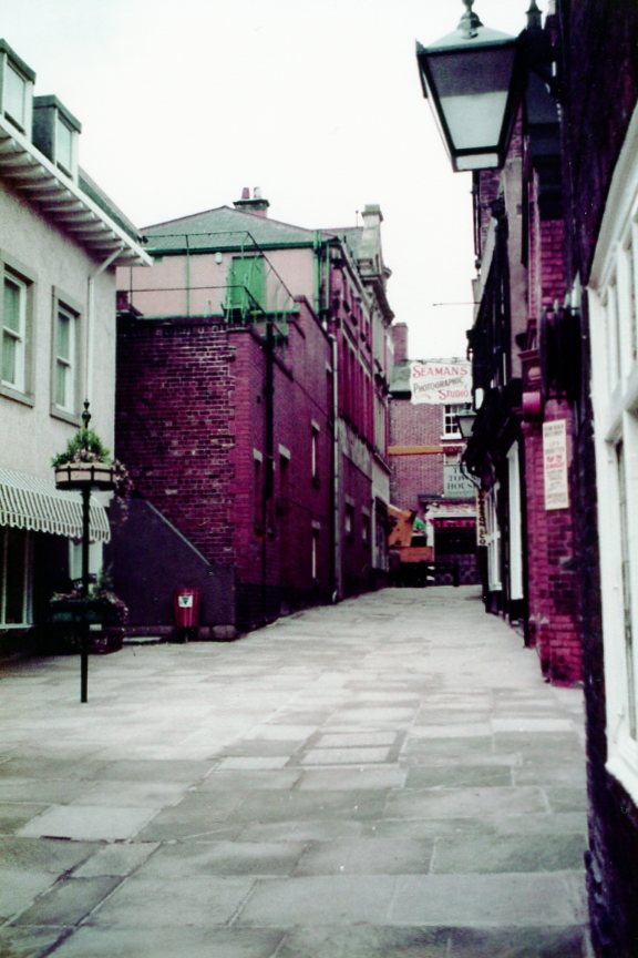
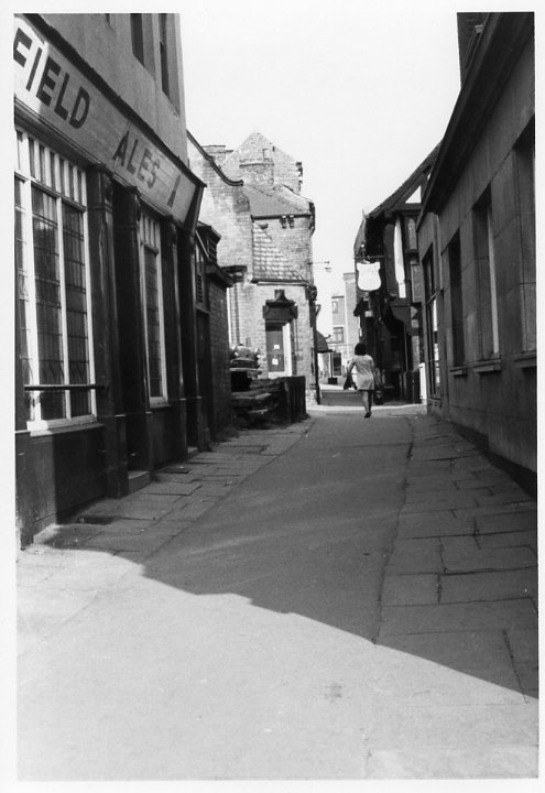
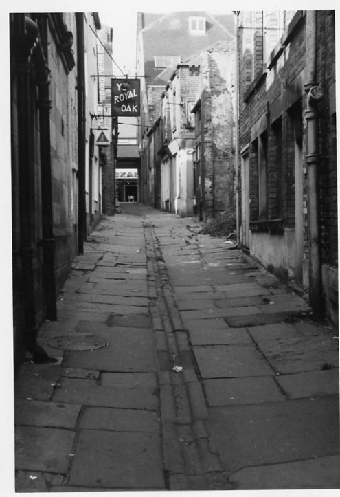
There’s little doubt that parts of Chesterfield had seen better days in the 1970s, including the Shambles. This was undoubtedly due to various schemes for comprehensive redevelopment that (fortunately) fell-through in the mid-1970s. We end this introduction to the area with two September 1973 photographs taken by the late Chris Hollis.

Our first view is of the central Shambles passage, looking from the Market Place end. To the right was what would then have been the premises of Lloyd’s Bank. To the left the Cathedral Vaults public house, which was sadly demolished in 1976. Beyond, to the right, is the Royal Oak public house. The oldest part of the building, the much-restored timber frame, is thought to have been added to the existing public house when it was restored in about 1900.  As we covered in an earlier Facebook post, there is no evidence to suggest that the Knights’ Templars stopped off here for a quick drink on their way to the Crusades!  However, they certainly had property holdings in the Shambles, which was possibly their largest estate in Chesterfield.
Our second photograph shows one of the north to south passages (looking northwards). Like the previous photograph there is a general state of decay.

The Cathedral Vaults public house (with its one-time neighbour) was accompanied by three other separate properties facing the Market Place. These were all probably re-fronted in the Georgian period, with pillared arcades on the ground floor.  The rear of the Vaults (seen below) was earlier – perhaps 17th century. Only one of these pillared structures survives – that on Low Pavement. The ‘Pretty Windows’ as the Vaults became known was subsequently rebuilt – it’s currently a pharmacy.


An introduction to the Shambles, Chesterfield Read More »

Stainsby school in the news – but what is its history?

The former Stainsby board school, November 2021.

The former board school at Stainsby is in the news at the moment as the National Trust seeks to sell the property. But what is its history? In this blog we’ll take a brief look.

Our Hardwick: a great house and its estate paperback, published in 2009 (out of print but available in local libraries), outlines the history of education in the Hardwick area.  In the 1860s the 7th Duke of Devonshire erected a new school and a house for the master at Stainsby on the site of the medieval manor house there. This replaced a building at the edge of Hardwick park, which became a private residence.

This wooden building in the school yard is current leased to a community organisation.

In 1893 a school board was formed for Ault Hucknall, Glapwell and Heath. This took over the duke’s schools at Heath, Stainsby and Rowthorne (along with a school at Doe Lea belonging to the Hallowes estate). All four were Church of England school and a Church school at Hardstoft continued on a voluntary basis.

In 1895 the school at Stainsby was pulled down and a new and larger building erected by the school board. Hardstoft school was rebuilt in 1894, Doe Lea four years later.

In 1903 county councils took over former board schools. What contribution had been made to local schools by the Hardwick estate fell away. The county council built some new schools in the area, following the development of colliery villages, such as Holmewood and later Bramley Vale. Most of the pupils at Stainsby came from the farming villages near Hardwick Hall.

Stainsby school closed following the opening of a new secondary school at Heath in 1960. This took older children from the former all-age school at Holmewood (perversely called ‘Heath School’, although few children from Heath attended), which became a primary school. The school at Stainsby became redundant and was closed. 

The school sits on the top of the medieval manor house’s site. The area is a scheduled ancient monument.

The building at Stainsby then became what we describe in our book as ‘an imaginative, if short-lived venture’ as a youth music and drama centre. The first warden was a former actor who lived in the headmaster’s house. The Stainsby Arts Centre served schools throughout north-east Derbyshire in the 1960s and early 1970s. From it grew the Stainsby Festival of folk music, which started in 1969 and has long outlived the arts centre.

Now the National Trust is, somewhat controversially, selling the former Stainsby school building by auction. The school board leased the land on which the school was built from the 8th duke of Devonshire. The freehold therefore passed to the National Trust with the rest of the Hardwick estate in 1958, after it was accepted by HM Treasury in lieu of death duties payable following the death of the 10th duke in 1950.

Ault Hucknall Parish Council and a consortium of community groups are trying to purchase the property, but may be outbid in the auction, which ends on 16 November 2021.

The Stainsby Festival used the old school site, but in 1974 a lessee of the school property did not want the festival. It then moved to nearby Brunt’s Farm. This programme from the 1976 event reveals that weekend tickets to the festival were then £3.00 each. Artists included Broadside, John Goodluck and Threefold. There were also workshops.
Visitors to the site will find of parts of it adorned with bunting, a banner and notices protesting at the National Trust’s decision to sell the property and urging potential bidders not to bid against the community‘s bid for the property.

Stainsby school in the news – but what is its history? Read More »

Water, Jam and locally produced histories

To end our short series on jam and preserves manufacturing we’re looking at a very small, basically one-man business, in Brimington, near Chesterfield. We’ll also look at how VCH doesn’t replace locally produced histories.

Two Kirkham & Hebdige bottles, that would have been filled with mineral water at their Coronation Road, Brimington premises. The ‘K&H’ site was subsequently used by a short-lived jam and preserves manufacturer.

Water and jam

The story starts when land, at the north end of Coronation Road, Brimington was sold to a Frederick Hebdige and Reuban Kirkham in 1903. They erected a small factory and stable on the land and made mineral water there. But by 1919 the property was for sale with the mineral water manufactory out of use. Our photographs shows two bottles from this short-lived affai

The property was sold to a consortium of people. Included were members of the Hicks family (who were grocers). And so the business styled as ‘The Corona Fruit Preserving Company’ started. (There is no connection, incidentally, with the well-known Corona soft drinks company).

William John Piece of Sanforth Street, Newbold, appears to have been the only active partner in the business, excepting another who acted as sole selling agent for the jam.

New buildings were added by the partners and the business was successful for a few years until 1921, when it made a loss. The partnership was dissolved in June 1921, but Pierce decided to take the whole business on. This was ultimately his undoing as in early 1923 he was filing for bankruptcy. There is no mention of the business in production after that date.

The jam factory, as it became known, was the cause of complaints from the parish council. In early in 1922 it was reported that ‘thick clouds of smoke’ were being emitted from the property, causing a nuisance.

No advertisements have ever been found for either the mineral water or the preserve manufactures and they weren’t listed in local trade directories.

You can find out a lot more about these two short-lived businesses in an article published by the Brimington and Tapton Local History Group – look for the Brimington and Tapton Miscellany 1 download – it’s contained in there.

Replacing history?

Our thanks to Brimington and Tapton Local History Group for pointing out this very small-scale business.

It’s certainly on a different scale to the previous preserves businesses we have looked at. Like the other two, though, it will certainly get a mention in our VCH Red Books.

But the VCH account won’t replace individual histories like that about the Brimington business. VCH can’t hope to go into the detail that individual accounts like that can. But what we will do is ‘signpost’ such accounts in our very thorough references.

We always look at reliable published sources, but will also examine original sources in our parish histories. We’ll undertake research that might well be beyond the average interested person. For example, trips to the National Archives in London can be very expensive and not everyone can read Latin.

If you’d like to find out more about us and how you might help in research please contact us. (And you don’t have to read Latin to get involved!)

Water, Jam and locally produced histories Read More »

Poor Law and poor tenants

Spotting this newspaper clipping from the Derbyshire Courier – Saturday 02 May 1840 on the Ashover History and Genealogy Facebook page prompted the obvious question: why were the Poor Law Commissioners ordering such sales to be made? A quick email to our Editor, Philip Riden, generated this explanation:-

“It’s probably to raise cash towards their share of building Chesterfield union workhouse. Ashover was put into Chesterfield union after 1834 and each township in the union had to find a share of the cost of the workhouse. If a township owned some property for the benefit of the poor, typically either a parish workhouse or cottages in which they used to house the poor, or from which they took rent to pay to the poor, which would not be needed for any of those purposes after the union workhouse was opened, the township was expected to sell the property. The proceeds would be credited to the township’s capital account with the union, thus reducing the amount they had to raise in rates to pay each year on capital account towards the cost of the workhouse.”

“Ashover had a union workhouse built under the 1785 Act (which provided for voluntary unions of parishes). I assume that was transferred to Chesterfield union after 1834 and sold by the Chesterfield guardians. This sale does not look to me like the old Gilbert Act workhouse at Ashover, and I would guess the cottages had ended up in the hands of the wardens and overseer and the rent was being used to reduce the poor rate for the parish. So they would have to be sold under the 1834 Act.”

Somewhat unfortunate for the tenants who would presumably have found themselves homeless after the sale and looking for somewhere else to live.

Poor Law and poor tenants Read More »

Are you following us?

A quick thanks to our followers. We’ve only been going since January on this website, but we hope you’re finding our content and posts useful and interesting.

Don’t forget to follow us on Facebook and that we also have a Twitter account.

We use Facebook for shorter news and items of interest. You’ll find the vast majority of our blogs on there too. On our Twitter account you’ll find feeds we share and create about general news in the world of VCH and local history.

Our latest Tweet and Facebook post has, for example, been about an important auction sale of the contents of Weston Hall, Northamptonshire. Until recently this was one of the homes of the Sitwell family, who are, of course, closely associated with Renishaw Hall, Derbyshire.

Are you following us? Read More »