Spital Leper Hospital, Chesterfield: a short history
Now and then there’s some debate regarding the leper hospital at Spital (in Hasland parish), so we thought we would try and address some of the questions asked about it in this blog – mainly a summary from information in our History of Hasland book.
The leper hospital, dedicated to St Leonard, from which the modern suburb takes its name, is first mentioned in 1195. Historically it was just outside the old borough of Chesterfield, in the large parish of Hasland.
After the Dissolution, the site and buildings were granted to George 6th earl of Shrewsbury, the lord of the manor of Chesterfield between 1560 and 1590, and its lands were merged into the manorial estate.
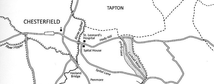
Where was the hospital?
William Senior’s survey of 1633 marks a large farmstead named Spittle, with a house on one side of a quadrangular range of buildings, on the north side of the main road from Chesterfield to Bolsover at the foot of Hady Hill, opposite the end of Spital Lane. This tenement is assumed to stand on the site of the hospital, although it is possible that the hospital was moved early in its life.
A deed probably dating from the end of the reign of Henry III (1216–72) conveys 2½ acres of land and a ‘holme’ (probably meaning an island) at Reynolf’s bridge, where the old hospital formerly was. The tenement known as Spittle in fact stood very close to Spital Bridge, on the main road leading east out of Chesterfield, which seems likely to be the bridge referred to in the deed. If so, what exactly the reference to the ‘old hospital’ means, or how far it moved, is unclear.
Few other properties at what became the settlement known as Spital are denoted on William Senior’s survey of Chesterfield (1633). Apart from the Spittle and the house opposite, the only other settlement marked by Senior in this area was a tenement named ‘Bell’s House’, at the top of Hady Hill.
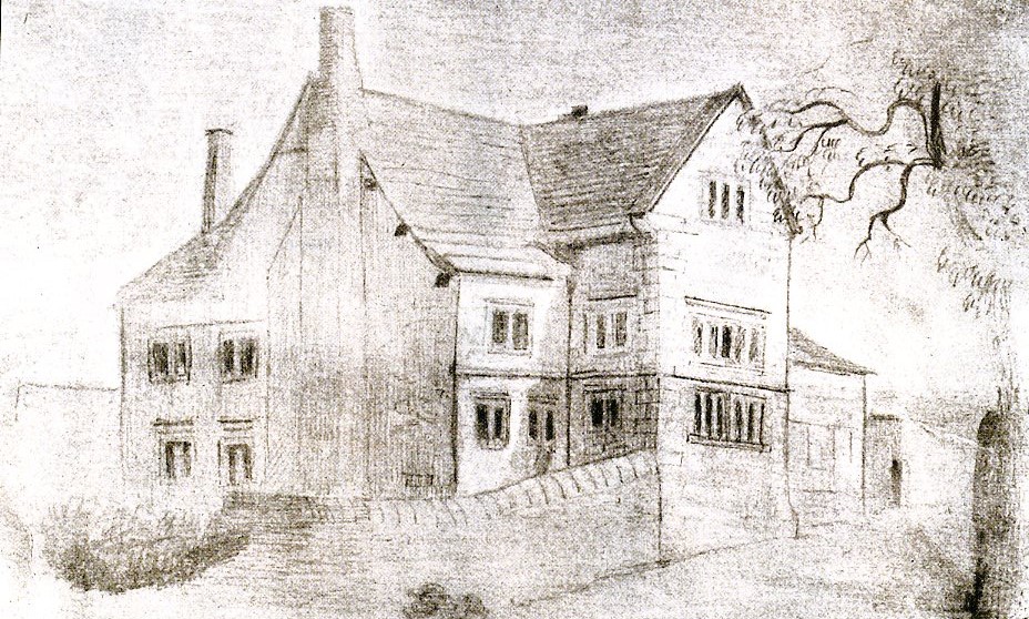
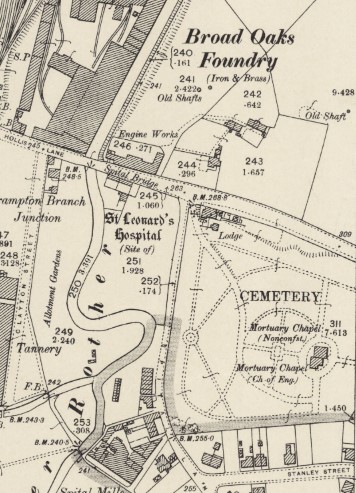
Around 1850 the sister of local businessmen and worthy TP Wood sketched a 17th century built stone house near the junction of Hady Hill and Spital Lane. It was supposed, almost certainly incorrectly, to occupy the site of the medieval leper hospital. Instead, it probably showed a house near the hospital site known as Spitalfield. This house stood within the area acquired in 1857 for the building of Spital Cemetery and was demolished to make way for the lodge. The inference made by Wood may be responsible for Ordnance Survey maps denoting the site of the leper hospital in this area – whereas it was more likely to have been on the opposite side of Hady Hill, although Spitalfield house and the land on which it stood may have been part of the former hospital estate.
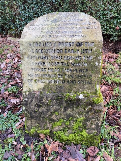
A priest’s burial
Adding to the available leper hospital site evidence was the discovery of a skeleton in the grounds of number 16 Hady Hill in 2000. It was thought that the person buried may well have been a priest at the hospital. He was buried in a ‘composite stone coffin’ with a paten and a chalice.
During excavations, evidence was found of a wall, thought likely to have been part of the southern wall of a chapel. Consequently, was thought that the priest, aged about 50, may have been buried inside a chapel to the hospital.
The priest was buried some time between the late 12th and the early 13th century. The bones were subsequently reinterred in Spital Cemetery – the site is marked by a simple head-stone, situated near to the gatehouse, illustrated in this blog.
Rumours
There have been stories of timbers reclaimed from the hospital and used elsewhere. This was presumably enhanced by TP Wood recording in his Alamac for 1903 a tradition that oak beams from the Spittle farmstead had been removed and incorporated into a barn at Dobbin Clough Farm.
Now and again the perhaps age-old rumours of secret tunnels from the hospital (and indeed from elsewhere) to the parish church reoccur. The phenomenon of secret passageways is not confined to Chesterfield. These can be dismissed as rubbish – despite extensive building and more recently properly undertaken archaeological excavations – no evidence for these tunnels has been found.
A more detailed history?
For a fully referenced and detailed history we would refer you to the account in our History of Hasland book, but briefly the leper hospital was originally endowed by King John, when he was count of Mortain between 1189 and 1199 (during the reign of his brother, King Richard I), with the dues from the markets and fairs of the borough. In 1195 this was replaced by a rent charge of £6 on the manor of Chesterfield. In the first year of his reign John granted protection to the lepers of Chesterfield; in 1206 the income due to the hospital from the manor was £6 10s.; and in 1207 the king confirmed to the ‘Blessed Leonard and to the infirm of Chesterfield’ the rent charge granted a decade earlier.
Other early references include 1225 when the Crown gave 5 marks for the infirm of Chesterfield. In the same year a Gilbert was named as chaplain of the infirmary at Chesterfield. Three years later the king granted two oaks from the royal forest at Carburt on (Nottinghamshire) for the repair of the chapel at the hospital, and in 1230 assigned 6 acres of pasture in Peak Forest to St Leonard’s.
The hospital was one of a number of houses in Nottinghamshire and Derbyshire which in 1246 received a gift of pigs from the stock at Nottingham castle. A grant of protection of 1276 to ‘the hospital of St Nicholas’ appears to be a simple error; there was no other hospital in Chesterfield and the house at Spital is consistently said to be dedicated to St Leonard. In 1291 its annual value was given as £6 13s. 4d. The appointment of the hospital’s master was vested in the lord of the manor. Thereafter there are a string of references to the hospital, all alluded to in our Hasland book. Including an ownership dispute in 1531 between George Talbot, 4th earl of Shrewsbury as part of an exchange of estates between Shrewsbury and the countess Salisbury. This dispute was still in progress in 1535.
After it was dissolved the hospital and its lands passed to the Crown. The estate was sold in 1588 and was later absorbed into the manorial estate.
As has been alluded to above, details on when the hospital buildings were actually demolished are not available.
Sources for this blog
‘History of Hasland …’ Derbyshire VCH/Merton (2022) – which is fully referenced.
Annsofie Witkin ‘Excavation and analysis of a skeleton from Hady Hill, Chesterfield, November 2000’, ARCUS/Chesterfield Museum (2000).
Monument record MDR5343 – St Leonard’s Hospital (site of), Chesterfield [0n-line].
Our Hasland book is now out-of-print, but you will find copies in Chesterfield Local Studies Library.
We edited this blog on 14 January 2024, to remove confusing references to possible burial of the priest in the 14th or 15th centuries – which were contained in the original Witkin (2000) report cited above.
ENDS
Spital Leper Hospital, Chesterfield: a short history Read More »