
Our VCH county editor has recently written a very brief overview of how Staveley initially developed.
There’s never really been a serious account of Staveley’s history. At VCH we’d like to put this right. Indeed, we started work on this town but had to concentrate our resources elsewhere.
A planning application been submitted to convert the former Elm Tree public house on High Street into dwellings, with further residential building on the surrounding land. As part of comments from the Chesterfield and District Civic Society on the application, which is in a conservation area, a very brief overview of the parish has been written by our county Editor – Philip Riden. We hope you will be interested in this, which we share below.
How Staveley grew
The village of Staveley grew up on the right bank of the Rother at a point where the main road running north-east from Chesterfield (the modern A619) divides into two. Historically, one arm (today the B6053) ran north through Beighton to a crossing of the Don at Rotherham and the other continued eastnorth-east to Bawtry, at the head of navigation on the river Idle, crossing on its way the route which runs along the magnesian limestone ridge between Rotherham and Mansfield (A618/B6417) and the Great North Road.
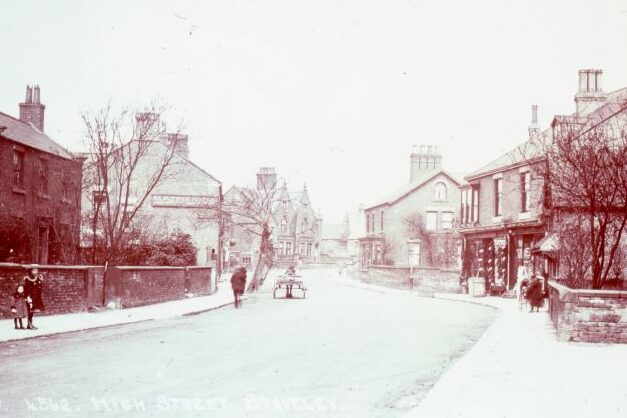
At the southern entrance to the village a minor road (the modern High Street) branches from the main road to run north parallel with it, before turning east (as Church Street) to rejoin the main road. The parish church and manor house were built on the north side of Church Street. If a map of 1783 (reproduced in A. Court, Staveley: my native town (1946) from an original at Chatsworth) is a reliable guide to earlier settlement, most of the houses in the village stood on either side of High Street and the south side of Church Street, with more limited building on Duke Street. The map also marks the modern Porter Street, which connects Duke Street with High Street at roughly the mid-point of these two roads. The main road between the junctions with High Street and Duke Street is today known as Market Street, but there was no medieval market in Staveley.
Romano-British settlement
Traditionally, it was assumed that there was little or no Romano-British settlement on the heavy clay soil of the Coal Measures of north-east Derbyshire, but this view has been modified in recent years with the discovery of a farm alongside the A61 at Wingerworth, and (of greater relevance here) slight evidence for settlement at a site in Brimington, between Chesterfield Road and North Moor View. If there was Romano-British settlement at Brimington, there may have been at Staveley as well, where inconclusive evidence of Roman occupation was found during excavations at Staveley Hall in 2006. If such occupation could be confirmed, it would prompt fresh thoughts about the use of routes from Chesterfield to the Don and the Idle in the Roman period, since both may have been used to export lead smelted in the Peak.
The Elm Tree
On the Elm Tree itself, our editor notes that initial investigations on the site, as part of the planning application, did not find any evidence of Roman occupation but the possibility is worth bearing in mind if further work is undertaken.
The inn stands on the west side of High Street opposite the end of Porter Street. It occupies a wide plot, which would originally have run down to the Rother. Its width means that the pub yard extends alongside as well as behind the building. The plot is clearly shown on the map of 1783, with a substantial T-plan building on it, with access to a rear yard at its southern (left-hand) end. The present pub building appears to date from the middle or late nineteenth century. The Elm Tree is listed in county directories from at least 1888 but does not appear in that of 1857.
More work on Staveley’s history
We’d like to carry-out further work on Staveley in due course, but this depends on our available resources. If you’d like to join us in this work please contact our county editor.
The Elm Tree planning application is reference CHE/21/00778/FUL. You can view the civic society’s full response here.