
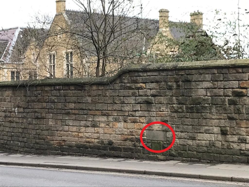
We’re taking a look at medieval Chesterfield’s chapels in this blog. All have now disappeared, with only one marked by a small plaque in a wall on Sheffield Road.
These chapels were positioned on major routes so that travellers might say a prayer for safe delivery on the journey they were about to start. They would then pay a monetary offering.
Apart from the leper hospital near Spital Bridge, there was a chapel at the bridge on Lordsmill Street, one in the old market place (i.e. not the present Market Place) and a third on Sheffield Road.


A small chapel dedicated to St Thomas Becket stood on the edge of the old market place between Holywell Street and what was Knifesmithgate. It was first mentioned in 1465-6 but dates from much earlier. It does not seem to have been connected with any of the gilds and chantries of the medieval town. The last remains seem to have been removed in the 1830s.

Perhaps the best known chapel, dedicated to St Helen, was on Sheffield Road, just outside the built-up area, but in medieval times some way out of the town centre. St Helen’s was supported by a small gild with a modest endowment of land and buildings. As we have covered in our blog on Chesterfield Grammar School, it was taken over by that institution in the 1590s. In 1714 Chesterfield Corporation built a new schoolhouse on the site. As with St Thomas’s, no illustrations of St Helen’s chapel are known.
The third chapel was established by the earl of Salisbury at the southern approach to the town on the bridge over the river Hipper. This was dedicated to St Mary. The earl was lord of Chesterfield at the time. Slight remains survived as late as the 1780s, but, once again, no illustrations survive. We don’t know exactly where the chapel was, but think it would have been on the town side (north) of the Hipper and on the downstream (east) side of Lordsmill Street


After chapel foundations of this sort were dissolved in 1548 the burgesses gave the three chapels to the the 5th earl of Shewsbury, then lord of the manor. St Helen’s chapel was returned to them, which became home to the newly established grammar school. Both the St Thomas’s and St Mary’s chapels were absorbed into the manorial estate.
Neither of Chesterfield’s two main gilds, dedicated to St Mary and to the Holy Cross, had their own chapel or gildhall, and so must have worshipped at altars in the parish church. There was a much smaller Smiths’ gild, which must have done the same. Guilds were groupings of religious or crafts-based people, who gave mutual support to each other.
Chantries were later founded in Chesterfield by wealthy landowners who provided an endowment of land, the income from which covered the wages of a priest to say masses and prayers, usually for the endowment founder’s soul. They too had chapels or altars in the parish church, rather than a separate building, although there was a chantry house in the south-west corner of the churchyard, where the chantry priests lived.
Today these chapels are another forgotten part of our history. Only one is marked today by a simple stone included in the boundary wall to the former (and aptly named) St Helena School – now the University of Derby on Sheffield Road – the site of St. Helen’s chapel.
We’re grateful to Chris Leteve for additional research and photographs in this blog.

This blog was revised 9 February 2022 correcting the position of the Lordsmill Street bridge and chapel. It was further updated on 29 August 2023 to make the supposed position of the chapel to St Thomas Becket clearer.
try spell check on guild. the bridge illustration appears to show North bound traffic.
Thanks for commenting on our post. Though ‘guild’ is in more common use, ‘gild’ is generally used by our county editor – both have the same meaning. On the illustration – the traffic in the lanes referred to is heading southbound on the A61.
Pingback: Eyres of Chesterfield's sad demise - Derbyshire Victoria County History