
In this blog we take a brief look at why Hasland (the subject of a forthcoming VCH spin-off book) was once a more extensive area than it is generally recognised as being today.
What do we mean by parishes and townships?
We’ll start by explaining about what we mean as a parish.
Our ‘big red books’ are made up of chapters on individual parishes; a ‘parish’ for this purpose means an area which formed a separate administrative unit at the time of the 1831 census. In England north of the Trent, these units frequently do not coincide with the boundaries of ecclesiastical (i.e. church) parishes and so should more accurately be called ‘townships’.
The twelve townships of Chesterfield
The ‘ancient parish’ of Chesterfield (meaning the parish as it existed in 1801) was made up of twelve townships. The smallest was the borough of Chesterfield, occupying 312 acres at the centre of a parish of over 24,000 acres. The others formed a ring round the borough, including (working clockwise from the north) Whittington, Brimington, Tapton, Calow, Hasland, Temple Normanton, Wingerworth, Walton, Brampton and Newbold.
There are two other complications. In the early Middle Ages, because of the distance of some parts of the parish from the parish church, chapels were founded in several of the townships. In three cases – Brampton, Whittington and Wingerworth – the landowners who built these chapels tried to establish the townships they served as independent parishes. This was resisted by the dean of Lincoln (the lay rector of Chesterfield), as it would have reduced his income from tithes. Whittington came closest to being regarded as a separate parish, while Brampton and Wingerworth achieved a degree of autonomy as parochial chapelries.
The Church of England modernised its parochial structure in the 19th century. Brampton and Wingerworth became ‘new parishes’ and most of the rest of the ancient parish of Chesterfield was divided up into similar units.
The second complication arises from the progressive extension of the boundaries of the borough of Chesterfield, which until 1892 were the same as those of the township. The borough was extended in that year; again in 1910 and 1920. This marched roughly (but not exactly) in step with the expansion of the built-up area. The final boundary alteration in 1974 added two civil parishes to the borough – Brimington and Staveley. The former was part of the ancient parish of Chesterfield but the latter has no historical connection with the town.
Today, most of the ancient parish lies within the borough, although the whole of the former townships (later civil parishes) of Calow, Temple Normanton and Wingerworth, and parts of Hasland, Walton and Brampton, are in North East Derbyshire district.
Hasland’s further complications
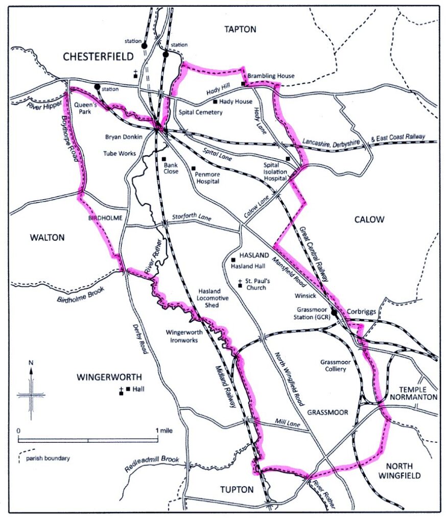
Turning to the township of Hasland, there are further complications. Today, the name ‘Hasland’ refers to a densely populated suburban settlement south-east of the town centre. This has developed, mainly since the late 19th century, from an older hamlet at the junction at which a road to North Wingfield branches off from the historic main road from Chesterfield to Mansfield. The township of Hasland, however, covered a much bigger area (see our map above), in which several other quite distinct settlements have come into existence in the same period. The largest of these is Grassmoor but the township also includes Spital, Hady, Winsick and part of Corbriggs (the rest of which is in Temple Normanton).
Even more confusingly, Hasland is the only township in Chesterfield ancient parish to include land both east and west of the river Rother, which otherwise, from Whittington in the north to Wingerworth in the south, forms a township boundary.
West of the Rother the township included the suburb which grew up in the late 19th century on either side of Derby Road between the junction of Lordsmill Street and Hasland Road in the north and the bridge over Birdholme brook just beyond the junction with Langer Lane in the south. This settlement was simply known as ‘Derby Road’ when it first developed. But in the 20th century came to be called Birdholme. Much of the land of the township west of the A61 was used to build a large local authority housing estate in the 1920s, near the church of SS Augustine, which explains why part of the district is sometimes called ‘St Augustine’s’.
Complications with medieval manors
Lastly, it’s impossible to explain modern place-names without touching on the complexities of medieval manors within Chesterfield ancient parish.
As Chapters 1 and 2 in our book will explain, Hasland is the only township in the parish which does not appear in Domesday Book as either a manor in its own right or an outlying member of a manor. What later became known as the ‘manor of Hasland’ was in fact part of the manor of Chesterfield in the Middle Ages. This included most of the land of the township east of the Rother.
All the land on the other side of the river, and a small portion on the east as far as Hasland Road and Storforth Lane, lay within the manor of Boythorpe. In the opposite direction the lands of the manor extended to the township boundary at Boythorpe Road, but did not include the area between there and Walton Road. This was also developed for housing in the 1920s, when it became known as Boythorpe. The modern suburb, however, was not part of the medieval manor of the same name and lies entirely in the historic township of Walton.
We hope you’ve found this overview as to why Hasland’s boundaries have changed over the years. It’s mainly taken from the preface to our new book on Hasland which we hope to publish in May.