Our Victoria County History spin-off book on Hasland, after some delay, is in the final stages of preparation. You can find out more about the book in this blog.
Our VCH County Editor – Philip Riden – has brought together hours of work by our Chesterfield research group, for the first authoritative history of this expansive parish. It’s written in our usual VCH style, which means there’s lots of source references and a thorough index for those wishing to explore more about the story of Hasland.
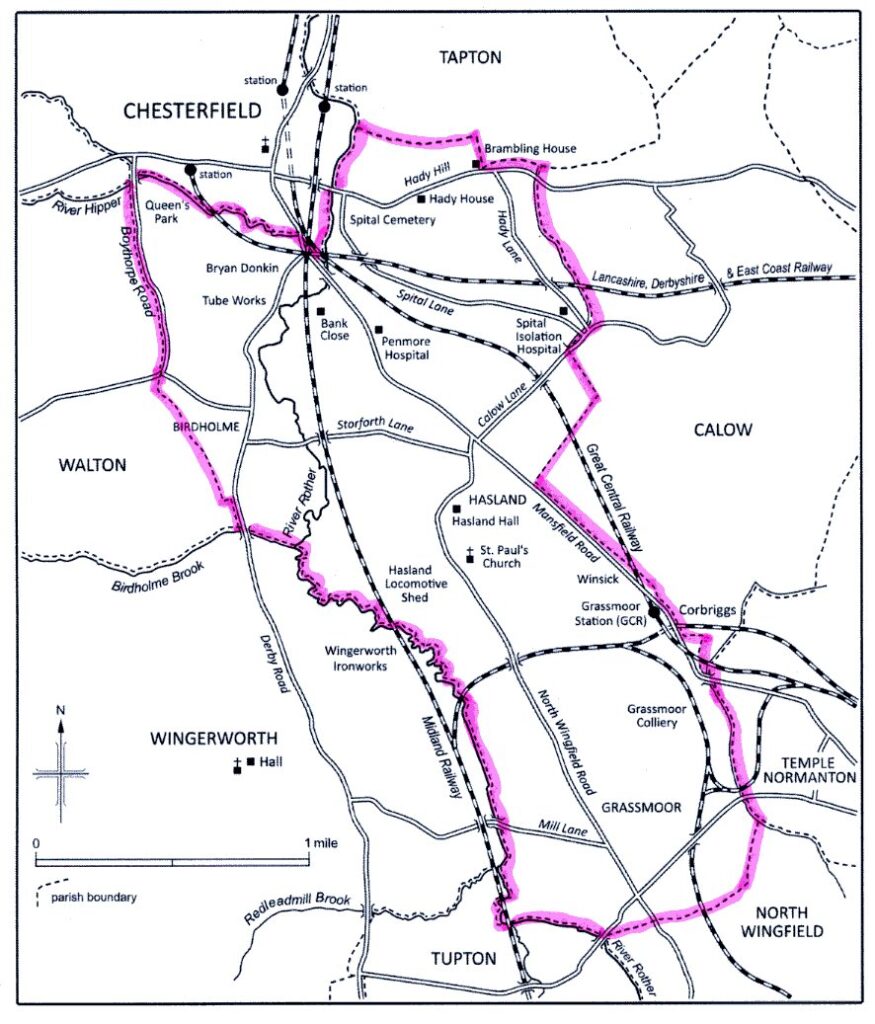
Hasland, but not as you know it? Our book will cover the once historic parish – marked by the highlighted boundary. It was much bigger than what we now regard as Hasland.
But what many people now regard as the modern Hasland, was much more extensive. Our map above (from the book) shows just how big Hasland parish once was. At one time it comprised not only what we now call Hasland but also Grassmoor, Winsick, Spital, Hady, parts of Boythorpe and Birdholme. It also included much of Chesterfield’s former heavy industry including the Tube Works and Bryan Donkin’s premises on Derby Road. No wonder the book will number some 200 odd pages.
As is standard in VCH, there’s sections on landownership, economic, social and religious history and local government. Within these sections are histories on such diverse topics as the Reema concrete plant based at the former Broad Oaks blast furnaces (itself covered), SS Augustine’s church and other places of worship, local collieries, Penmore hospital and many others. Lessor remembered features such as the Grassmoor and Hasland cinemas, tobacco and textile manufacture also feature.
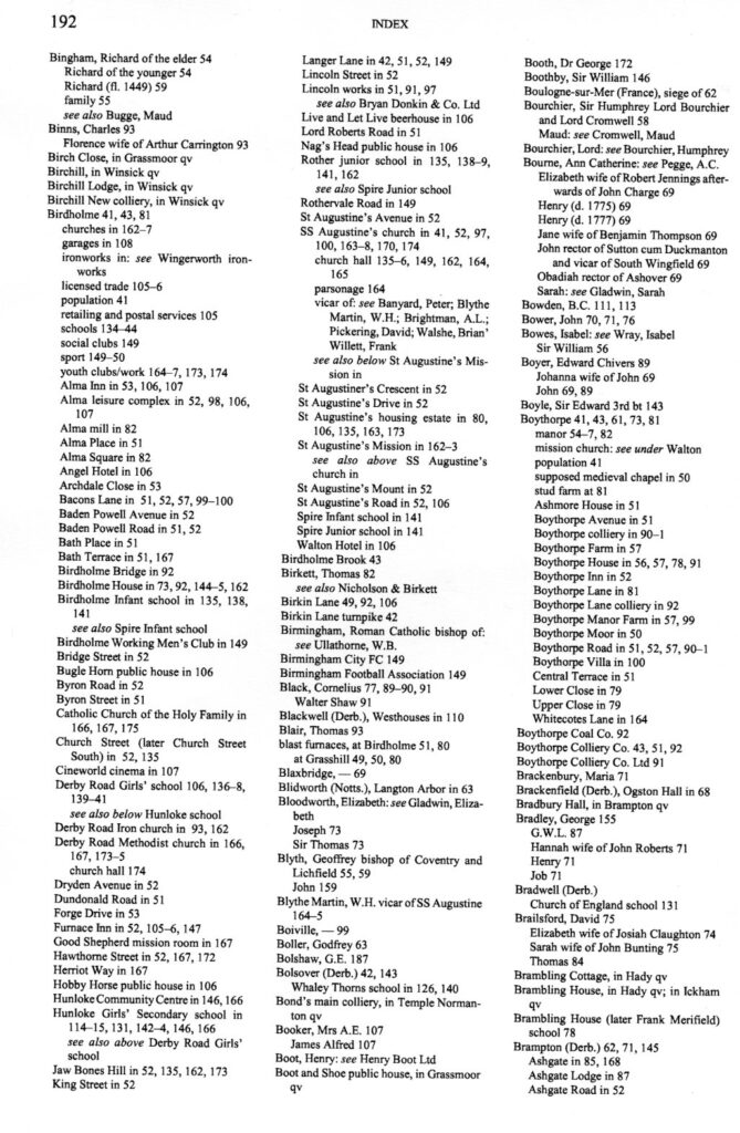
Our second extract from the book is a page from the index, which gives a snap-shot of a few of the items covered. Illustrations and maps will also feature in the publication.
A sample page from the index to our Hasland book.
We’ll be keeping you up-to-date with progress on the book, which should be published around May this year. In the meantime we’ll feature some of the stories from the publication in our blogs.
This is the second VCH spin-off publication. Our first – ‘Chesterfield Streets and Houses’ – is still available.
We’re taking a look at medieval Chesterfield’s chapels in this blog. All have now disappeared, with only one marked by a small plaque in a wall on Sheffield Road.
These chapels were positioned on major routes so that travellers might say a prayer for safe delivery on the journey they were about to start. They would then pay a monetary offering.
Apart from the leper hospital near Spital Bridge, there was a chapel at the bridge on Lordsmill Street, one in the old market place (i.e. not the present Market Place) and a third on Sheffield Road.
In this early 19th century view of the corner of Cavendish Street and Holywell Street, the Blue Bell public house is to the right, whilst the soon to be extended Eyres is to the extreme left. The small chapel dedicated to St Thomas was in this latter area– round the corner to the extreme left of the photograph.This large scale Ordnance Survey map extract of 1875 marks the supposed site of St Thomas’s Chapel on Holywell Street. The former Eyre’s furniture store is built on its site.
A small chapel dedicated to St Thomas Becket stood on the edge of the old market place between Holywell Street and what was Knifesmithgate. It was first mentioned in 1465-6 but dates from much earlier. It does not seem to have been connected with any of the gilds and chantries of the medieval town. The last remains seem to have been removed in the 1830s.
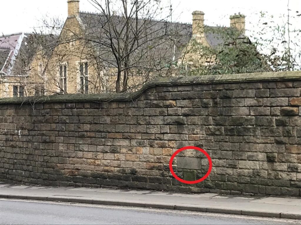
This simple stone is situated in the boundary wall to the University of Derby on Sheffield Road. The former Chesterfield Grammar School, now Chesterfield College, is the background. How many people have passed it unnoticed?Although the plaque is in the boundary wall of the University of Derby complex the site of the chapel was always shown on Ordnance Survey maps as being closer to the former Grammar School
Perhaps the best known chapel, dedicated to St Helen, was on Sheffield Road, just outside the built-up area, but in medieval times some way out of the town centre. St Helen’s was supported by a small gild with a modest endowment of land and buildings. As we have covered in our blog on Chesterfield Grammar School, it was taken over by that institution in the 1590s. In 1714 Chesterfield Corporation built a new schoolhouse on the site. As with St Thomas’s, no illustrations of St Helen’s chapel are known.
The third chapel was established by the earl of Salisbury at the southern approach to the town on the bridge over the river Hipper. This was dedicated to St Mary. The earl was lord of Chesterfield at the time. Slight remains survived as late as the 1780s, but, once again, no illustrations survive. We don’t know exactly where the chapel was, but think it would have been on the town side (north) of the Hipper and on the downstream (east) side of Lordsmill Street
Circled is the probable site of the bridge chapel on Lordsmill Street on this 1876 Ordnance Survey 6-inches to one mile map. The ‘gas works are those of the Midland Railway; ‘tannery’ on Clayton Street is that of Joseph Clayton. (Derbyshire Sheet XXV.NW, surveyed: 1876, published: 1883. Courtesy National Library of Scotland – Map Images (nls.uk)Our best calculation for the position of the centre of the old bridge on Lorsdmill Street is between the two painted arrows in lanes two and three of the southbound A61.
After chapel foundations of this sort were dissolved in 1548 the burgesses gave the three chapels to the the 5th earl of Shewsbury, then lord of the manor. St Helen’s chapel was returned to them, which became home to the newly established grammar school. Both the St Thomas’s and St Mary’s chapels were absorbed into the manorial estate.
Neither of Chesterfield’s two main gilds, dedicated to St Mary and to the Holy Cross, had their own chapel or gildhall, and so must have worshipped at altars in the parish church. There was a much smaller Smiths’ gild, which must have done the same. Guilds were groupings of religious or crafts-based people, who gave mutual support to each other.
Chantries were later founded in Chesterfield by wealthy landowners who provided an endowment of land, the income from which covered the wages of a priest to say masses and prayers, usually for the endowment founder’s soul. They too had chapels or altars in the parish church, rather than a separate building, although there was a chantry house in the south-west corner of the churchyard, where the chantry priests lived.
Today these chapels are another forgotten part of our history. Only one is marked today by a simple stone included in the boundary wall to the former (and aptly named) St Helena School – now the University of Derby on Sheffield Road – the site of St. Helen’s chapel.
We’re grateful to Chris Leteve for additional research and photographs in this blog.
Our ‘Chesterfield Streets and Houses’ book is still available from Chesterfield Museum, price £20, from the tourist information centre and the Chesterfield branch of Waterstones, or direct from the publisher (mertonpriory@btinternet.co.uk)
This blog was revised 9 February 2022 correcting the position of the Lordsmill Street bridge and chapel. It was further updated on 29 August 2023 to make the supposed position of the chapel to St Thomas Becket clearer.
What was a life in farming like on the Hardwick estate in the 1860s? In this blog we’ll take a brief look at this now forgotten aspect of country life, courtesy of our Hardwick a great house and itsestate paperback (2009).
J.J. Rowley, who lived at Hall Farm, Rowthorne, wrote extensively about the area in the 1860s. He was one of the inspectors for the Second Report of Commissioners on Employment of Children, Young Persons and Women in Agriculture, etc. , published in 1868-9.
Hall Farm, Rowthorne, home of J.J. Rowley, who wrote extensively about the area in the 1860s.
Rowley reported that in the 1860s adult male farm labourers worked from 6.30 am to 5 pm in the summer. They took their ‘bait’ (break) from mid-day for about 1½ hours. Winter work was, as might be imagined, different, with an 8 am start, no break, and finish at 4 pm. For a few weeks during spring, boys aged nine to 12 were employed to tend birds or lead horses. They earnt 6d. or 8d. a day for this. The boys were only deemed ready for heavier work from the age of 13. Women and girls were only employed during harvest.
Labourers living in their own cottages could earn 14s. to 16s. a week. Single men lodging could make £8 to £16 a year, plus board and lodging. The men would also be busy working at the statute fairs, held in neighbouring towns.
As we say in our book ‘It was a world which in the 1860s was about to be transformed, although not entirely swept away, by the growth of large-scale coal mining.’
Looking at the small village of Stainsby, of the two-dozen households there, the census of 1871 shows seven headed by farmers, five by labourers, with three men employed on the Hardwick estate. In 1901, with 21 households in the village, Stainsby had nine households headed by farmers. There were three miners, a colliery labourer, a colliery blacksmith and a railway labourer.
Hall Farm. Rowthorne. Like other many other estate buildings it was probably built from locally quarried sandstone.
Stainsby’s character was hardly transformed. Nor was the village of Heath, also part of the Hardwick estate. But the coal industry spurred development in other areas such as the estate at Holmewood, built from the 1890s, on the edge of Heath parish. This was built to house miners at Holmewood colliery and the Hardwick Coal Company’s other pit at nearby Williamthorpe (the latter on the Hunloke family’s estate).
Looking from the top of Hardwick Old Hall, at one time it might have been possible to see the nearby coal mines and view industry across the valley. These concerns and many other mines nearby are now but a memory. The wheel has perhaps turned full circle. Industry on the remaining Hardwick estate is now, once again, agricultural. Whilst conditions are much better there is much less employment provided by agriculture than in Rowley’s time.
This map, taken from a 1950s guidebook to Hardwick Hall, shows that the property had plenty of nearby collieries – all now gone. Despite this proliferation of mining activity the character of the estate villages was hardly altered.Rowthorne is to the top left.
Can you help us unravel a bit of a mystery? The Hall Farm we’ve pictured above is opposite this block of farm buildings, which has a name plate on it ‘Hall Farm’. What’s the relationship and which one is the real Hall Farm?
This post was revised on 10 January 2021. We replaced illustrations of the presently named Hall Farm (the premises in the bottom picture) , with those of Hall Farm house.
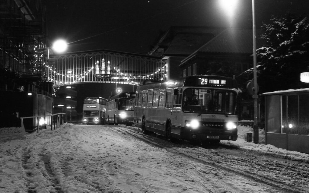
Here’s a photograph to brighten up your Christmas and new year (particularly if you’re sat at home and don’t have to trudge through snow!). It’s of a snow covered Elder Way in the 1980s.
Elder Way, Chesterfield, at night, in the 1980s.
At this time the two Chesterfield and District Co-operative Society buildings either side of Elder Way were linked by the bridge to the rear of the first bus. This was installed at first floor level when the society built a new supermarket and offices on what had latterly been bus stands on the corner of Elder Way and Saltergate. This new building opened in 1981. The offices were vacated some years ago, the supermarket closed within the last year or so. The building is now empty.
The bridge itself was removed when the former Co-operative store to the left was converted, at first and second floor levels, to a Premier Inn in 2019.
Chesterfield and District Co-operative Society was first formed in 1894. A familiar site in Chesterfield town centre, with branches across the district. The ‘Central Stores’ on Elder Way and Knifesmithgate were first opened in 1938. The building to the left was an extension opened in 1959. The society merged to become part of Midlands Co-operative Society in 2001.
Now the bridge has gone along with the once attractive Christmas decorations and a popular town centre department store, which sold everything from clothes, shoes, paint, electrical goods, furniture, toys, fancy goods, china, shoes, food and perfume.
After the First World War and especially after a comprehensive local Act of 1923 was obtained, some town centre streets were improved, created, lengthened and widened.
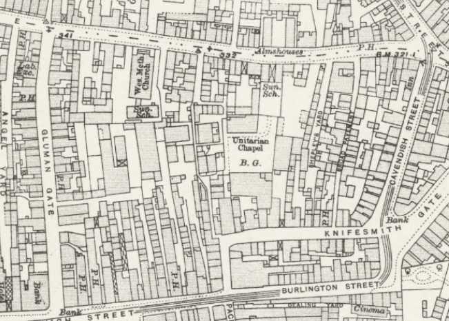
Large scale Ordnance Survey map from 1918, before Elder Way was created to run between a lengthened Knifesmithgate and Saltergate (to the top of the extract). The Unitarian Chapel and Wesleyan Methodist Church (now the Central Methodist Church) are survivors from these pre-improvement times.
As part of the same scheme, Elder Yard, a passageway leading from the top of Packers Row to Saltergate, was widened into a new road named Elder Way. Completion of the latter was accomplished in 1932. Around the same time the north side of Knifesmithgate was rebuilt with a particularly striking range of three-storey black and white buildings (the former Victoria Centre), in which the upper floors were jettied out over the entire width of the pavement to create a covered walkway. A smaller-scale building of the same kind was erected on the south side of the new section of Knifesmithgate near its junction with Packers Row.
Properties in Elder Yard mainly comprised cottages and houses of divided ownership, plus a mission chapel. The Unitarian Chapel dating from 1694 and a survivor of the new road, was once surrounded by properties of this type (incidentally, it’s still known as the Elder Yard Unitarian Chapel. But the yard has long-gone). Part of the old mission church property forms the forecourt of Elder Yard Unitarian Chapel.
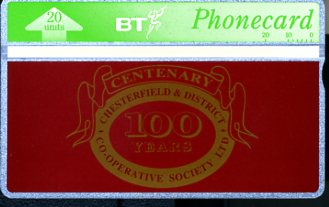
Remember BT phone cards? When the Chesterfield and District Cooperative Society celebrated its centenary in 1994, it produced a limited number of the cards, presumably as a collector’s edition. They included the logo adopted for their centenary year.
We’ve used our Chesterfield Streets and Houses book for much of the history in this blog, along with TF Wright’s History of Chesterfield, volume IV and the Chesterfield and District Co-operative Society’s centenary publication of 1994.
As this will be our last scheduled post of 2021. We’d like to take this opportunity to thank all our members, supporters and the readers of our posts. We hope you have a merry Christmas and a happy new year.
Chesterfield’s museum and Pomegranate theatre are set for a major revamp following the award of a substantial grant to upgrade the facility. In this blog we briefly review the history of the building – still known as the Stephenson Memorial Hall.
As part of the Chesterfield and District Civic Society’s submission to the planning application to update the facility our county editor (who is also chairman of the society) has written a short review of the building’s history. Below is an edited version.
Opening
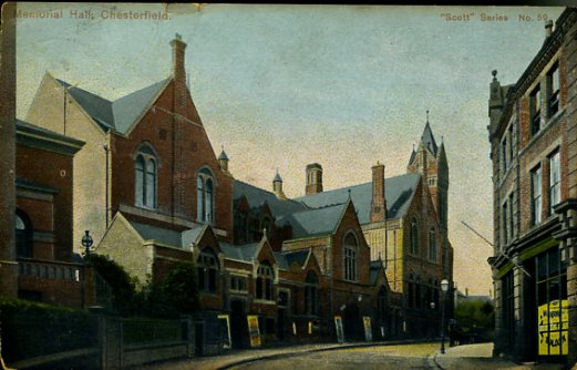
An Edwardian colourised postcard of the Stephenson Memorial Hall’s Corporation Street elevation. In the 1890s the corporation acquired the garden of Kilblean House, to the far left, using the land to build a stage, with a fly-tower and dressing rooms.
The Memorial Hall, opened in 1879, was built by the Chesterfield & Derbyshire Institute of Mining, Civil and Mechanical Engineers, founded eight years earlier, as their headquarters, although it was intended also to be used as a centre for technical education. The Chesterfield and Brampton Mechanics’ Institute also contributed.
Chesterfield Corporation made a contribution to the cost on condition that they could open a public library and reading room in the building. The Hall also became a centre for Cambridge University Extension Classes, which marks the beginning of non-vocational adult education in Chesterfield.
Rudimentary dressing rooms were provided for performers using the platform in the main lecture hall, but theatrical or musical entertainments were a very minor part of the plan. There was no bar or refreshment room in the original scheme.
The Stephenson connection
The building was named in memory of George Stephenson (1781–1848). For the last ten years of his life Stephenson leased Tapton House, just outside the town, and chose to be buried at Holy Trinity church on Newbold Road, rather than in his native North East. (Incidentally, Stephenson’s connection with Chesterfield, then as now, tends to be exaggerated somewhat).
George’s son Robert did not really maintain the connection with Chesterfield, nor with the coal and iron company his father founded at Clay Cross. Several of the leading members of the Chesterfield & Derbyshire Institute were also members of the Institution of Mechanical Engineers, founded by Stephenson in 1847, and obviously saw him as their hero, which is presumably why the Hall was dedicated to his memory.
Changes
The Hall was far too ambitious a venture for a small provincial engineering institute, especially in the slump which affected their industry in the 1880s. In 1889 the institute sold the building to Chesterfield Corporation for a sum equal to the debt left over from its construction.
In the 1890s the corporation acquired the garden of Kilblean House, which adjoins the Hall to the east, and used the land to build a stage, with a fly-tower and dressing rooms, to replace the platform in the main lecture hall. It was probably at this date that raked seating was introduced on the ground floor and an attempt made to remodel the gallery as a ‘circle’. These changes were not entirely successful and to this day the Pomegranate retains the character of a converted lecture hall, not a purpose-built theatre. The caretaker’s house on Station Back Lane also dates from this period.
A further change took place after 1901, when a new dual-purpose building was erected at the Grammar School on Sheffield Road, to be used during the day by the school and in the evening by technical classes previously accommodated in the Memorial Hall. This enabled the corporation to take over more rooms at the Hall, alongside the library. The main auditorium became the Corporation Theatre in 1904, although until just after the Second World War it functioned mainly as a cinema and was let to a commercial operator.
The council staff moved to the new Town Hall in 1938, allowing the library to expand into the whole of the western end of the building. (The council had offices and a council chamber in the Memorial Hall).
Full circle?
After the war the corporation resumed control of the theatre and reopened it in 1949 as England’s first local authority Civic Theatre, with a resident repertory company. The cost later became unsustainable and, after a period in which it was threatened with closure, the Borough Council refurbished the interior, renamed the theatre the Pomegranate, and from 1982 operated it as a receiving house and later a venue for live screenings. It is occasionally used for other events, notably the very successful annual Derbyshire Archaeology Day. This was originally a Sheffield University extramural day-school and so in that respect the Hall has come full circle to be used once again for adult education.
Finally, in 1984 the county council, which replaced the borough council as the library authority in Chesterfield in 1974, opened a new branch library on New Beetwell Street and the rooms at the Memorial Hall formerly occupied by the library became a museum, opened in 1994, which Chesterfield had previously lacked.
We previously posted about the missing statue of George Stephenson at the Memorial Hall in a previous blog.
The Chesterfield and District Civic Society’s full response to the planning application will be posted on their website. They have, incidentally, strongly objected to the museum’s proposed display reorganisation. This seems to adopt a ‘Character Driven‘ approach, instead of telling the chronological story of Chesterfield’s history by using objects, text and audio-visual displays.
Our sister organisation – the Derbyshire Record Society – has now fully published the Derbyshire Musters of 1638-9. All are fully indexed by person and place and prefaced by a detailed introduction. For case of handling, the introduction and indexes form one volume (part 1) and the texts another (part 2). The musters were edited by the late Victor Rosewarne.
Part 2 of the Derbyshire Musters of 1638-9 has just been published. Part 1 was published earlier in 2021.
Between the early sixteenth century and the mid seventeenth the Privy Council instructed local officials in each county to hold regular musters of able-bodied men who could be called upon to defend the kingdom in time of war. Men from every town and village had to assemble, usually in the early autumn, at a specified meeting place and show that they possessed suitable arms and armour. Gentry families had to provide horsemen. The musters were ordered by the lord lieutenant, summoned by the deputy lieutenants, and organised locally by the high constable of each hundred.
In 1638 the young 3rd earl of Devonshire had just become lord lieutenant of Derbyshire. Keen to impress the Council, the earl ordered the constables to compile lists of all men aged between 16 and 60 in each town and village, which he had copied into a volume to be sent up to London. The book, containing some 17,300 names, survives among the records of the State Paper Office. It provides a uniquely full record of the inhabitants of every community in Derbyshire on the eve of the Civil War.
In part 2, the text of the 1638 muster book is printed in full, alongside a shorter roll of 1639 and some ancillary documents.
Publication of the musters should be an indispensable source for the study of family history in Derbyshire, as well as the demography of the county, and also sheds new light on local administration in the early seventeenth century.
A sample page from part 2 of the Muster Book; an extract from the 1638 muster. This shows part of the entry for Beighton and Chesterfield borough. Part 1 contains an introduction and a full index of names and places. (Courtesy Derbyshire Record Society.)
The two parts retail at £33 each, but members of the record society can obtain them at £20 for each part. For further details contact the society’s treasurer – treasurer@derbyshirerecordsociety.org or fill in the on-line order form.
Our VCH county editor has recently written a very brief overview of how Staveley initially developed.
There’s never really been a serious account of Staveley’s history. At VCH we’d like to put this right. Indeed, we started work on this town but had to concentrate our resources elsewhere.
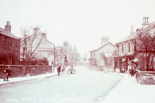
A planning application been submitted to convert the former Elm Tree public house on High Street into dwellings, with further residential building on the surrounding land. As part of comments from the Chesterfield and District Civic Society on the application, which is in a conservation area, a very brief overview of the parish has been written by our county Editor – Philip Riden. We hope you will be interested in this, which we share below.
The Elm Tree, High Street, Staveley is to the left in this Edwardian postcard. Note the tree outside the public house – which presumably gave its name to the pub.The building to the immediate left was replaced some years ago. (Collection the late Fred Wood).
How Staveley grew
The village of Staveley grew up on the right bank of the Rother at a point where the main road running north-east from Chesterfield (the modern A619) divides into two. Historically, one arm (today the B6053) ran north through Beighton to a crossing of the Don at Rotherham and the other continued eastnorth-east to Bawtry, at the head of navigation on the river Idle, crossing on its way the route which runs along the magnesian limestone ridge between Rotherham and Mansfield (A618/B6417) and the Great North Road.
At the southern entrance to the village a minor road (the modern High Street) branches from the main road to run north parallel with it, before turning east (as Church Street) to rejoin the main road. The parish church and manor house were built on the north side of Church Street. If a map of 1783 (reproduced in A. Court, Staveley: my native town (1946) from an original at Chatsworth) is a reliable guide to earlier settlement, most of the houses in the village stood on either side of High Street and the south side of Church Street, with more limited building on Duke Street. The map also marks the modern Porter Street, which connects Duke Street with High Street at roughly the mid-point of these two roads. The main road between the junctions with High Street and Duke Street is today known as Market Street, but there was no medieval market in Staveley.
Romano-British settlement
Traditionally, it was assumed that there was little or no Romano-British settlement on the heavy clay soil of the Coal Measures of north-east Derbyshire, but this view has been modified in recent years with the discovery of a farm alongside the A61 at Wingerworth, and (of greater relevance here) slight evidence for settlement at a site in Brimington, between Chesterfield Road and North Moor View. If there was Romano-British settlement at Brimington, there may have been at Staveley as well, where inconclusive evidence of Roman occupation was found during excavations at Staveley Hall in 2006. If such occupation could be confirmed, it would prompt fresh thoughts about the use of routes from Chesterfield to the Don and the Idle in the Roman period, since both may have been used to export lead smelted in the Peak.
The Elm Tree
On the Elm Tree itself, our editor notes that initial investigations on the site, as part of the planning application, did not find any evidence of Roman occupation but the possibility is worth bearing in mind if further work is undertaken.
The inn stands on the west side of High Street opposite the end of Porter Street. It occupies a wide plot, which would originally have run down to the Rother. Its width means that the pub yard extends alongside as well as behind the building. The plot is clearly shown on the map of 1783, with a substantial T-plan building on it, with access to a rear yard at its southern (left-hand) end. The present pub building appears to date from the middle or late nineteenth century. The Elm Tree is listed in county directories from at least 1888 but does not appear in that of 1857.
More work on Staveley’s history
We’d like to carry-out further work on Staveley in due course, but this depends on our available resources. If you’d like to join us in this work please contact our county editor.
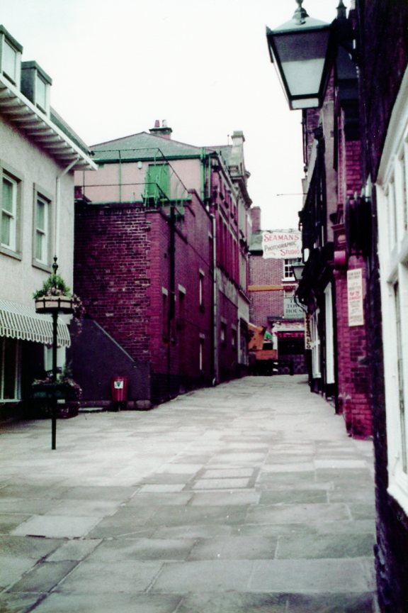
There’s a brief introduction to the Shambles area of Chesterfield in this blog. We also dispel the incorrect theory, often repeated, that the area was originally temporary market stalls which became permanent structures over a period of time.
Revitalised – part of the Shambles pictured in 1984, looking up towards High Street. (Chris Hollis)
There’s no evidence – as our ‘Chesterfield Streets and Houses’ book states – that the Shambles were originally market trader’s stalls that became permanent buildings over a period of time. It’s worth quoting from our book to give a short introduction to the area.
When the New Market was laid out in the late 12th century, an area at the eastern end of the Market Place was reserved for a large block of shambles, intended for butchers, fishmongers and possibly other traders who would have stood in the market every day, not merely on Saturdays. The block was bounded on the east by what is now Packers Row (which appears to have marked the western limit of the built-up area before the New Market was created), on the south by what is now Central Pavement (named by Potter in 1803 as Toll Nook, presumably referring to a place where tolls were collected at the eastern entrance to the market place), on the west by the Market Place itself, and on the north by High Street. The Shambles were roughly square, and consisted of a block of small buildings divided into eight groups, four on either side of a central east–west alley, which continues the line of Church Lane through to the Market Place, and presumably follows the route of the earlier road leading out of Chesterfield to the west (which today continues as West Bars at the opposite end of the Market Place). At right angles to this central alley three others ran from north to south. Six of the eight blocks of building thus created were probably originally of the same width (although some variation has developed over the centuries); the two westernmost blocks, fronting the Market Place, appear always to have been somewhat wider, to enable larger buildings to be erected on a more important frontage. Within the eight blocks, it is possible that each plot (apart from those facing the Market Place) was originally the same size, but by the early nineteenth century, when the Shambles were first accurately mapped, considerable variation had developed, presumably as a result of the amalgamation (rather than division) of the original plots. About twenty deeds relating to property in the Shambles dating from before c.1600 survive…
Philip Riden, Chris Leteve and Richard Sheppard, Chesterfield Streets and Houses, (2019) p. 109.
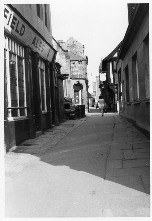
There’s little doubt that parts of Chesterfield had seen better days in the 1970s, including the Shambles. This was undoubtedly due to various schemes for comprehensive redevelopment that (fortunately) fell-through in the mid-1970s. We end this introduction to the area with two September 1973 photographs taken by the late Chris Hollis.
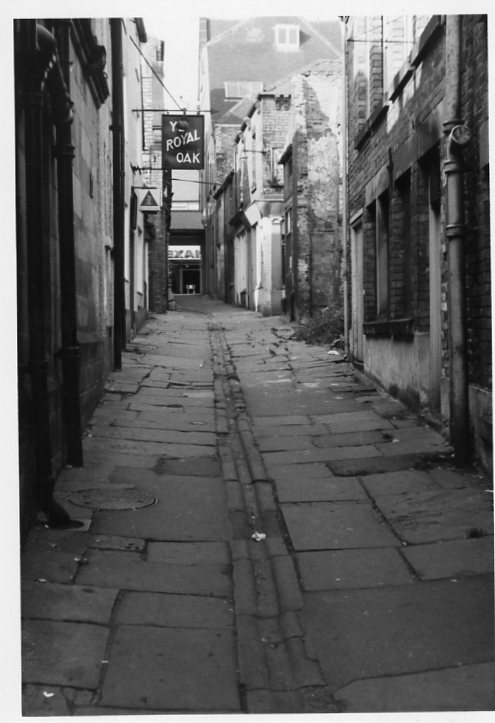
Our first view is of the central Shambles passage, looking from the Market Place end. To the right was what would then have been the premises of Lloyd’s Bank. To the left the Cathedral Vaults public house, which was sadly demolished in 1976. Beyond, to the right, is the Royal Oak public house. The oldest part of the building, the much-restored timber frame, is thought to have been added to the existing public house when it was restored in about 1900. As we covered in an earlier Facebook post, there is no evidence to suggest that the Knights’ Templars stopped off here for a quick drink on their way to the Crusades! However, they certainly had property holdings in the Shambles, which was possibly their largest estate in Chesterfield.
Our second photograph shows one of the north to south passages (looking northwards). Like the previous photograph there is a general state of decay.
The Cathedral Vaults public house (with its one-time neighbour) was accompanied by three other separate properties facing the Market Place. These were all probably re-fronted in the Georgian period, with pillared arcades on the ground floor. The rear of the Vaults (seen below) was earlier – perhaps 17th century. Only one of these pillared structures survives – that on Low Pavement. The ‘Pretty Windows’ as the Vaults became known was subsequently rebuilt – it’s currently a pharmacy.
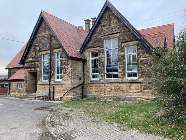
The former board school at Stainsby is in the news at the moment as the National Trust seeks to sell the property. But what is its history? In this blog we’ll take a brief look.
Our Hardwick: a great house and its estate paperback, published in 2009 (out of print but available in local libraries), outlines the history of education in the Hardwick area. In the 1860s the 7th Duke of Devonshire erected a new school and a house for the master at Stainsby on the site of the medieval manor house there. This replaced a building at the edge of Hardwick park, which became a private residence.
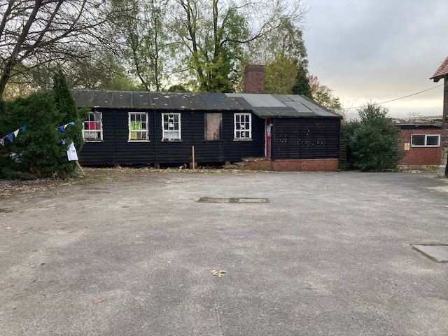
This wooden building in the school yard is current leased to a community organisation.
In 1893 a school board was formed for Ault Hucknall, Glapwell and Heath. This took over the duke’s schools at Heath, Stainsby and Rowthorne (along with a school at Doe Lea belonging to the Hallowes estate). All four were Church of England school and a Church school at Hardstoft continued on a voluntary basis.
In 1895 the school at Stainsby was pulled down and a new and larger building erected by the school board. Hardstoft school was rebuilt in 1894, Doe Lea four years later.
In 1903 county councils took over former board schools. What contribution had been made to local schools by the Hardwick estate fell away. The county council built some new schools in the area, following the development of colliery villages, such as Holmewood and later Bramley Vale. Most of the pupils at Stainsby came from the farming villages near Hardwick Hall.
Stainsby school closed following the opening of a new secondary school at Heath in 1960. This took older children from the former all-age school at Holmewood (perversely called ‘Heath School’, although few children from Heath attended), which became a primary school. The school at Stainsby became redundant and was closed.
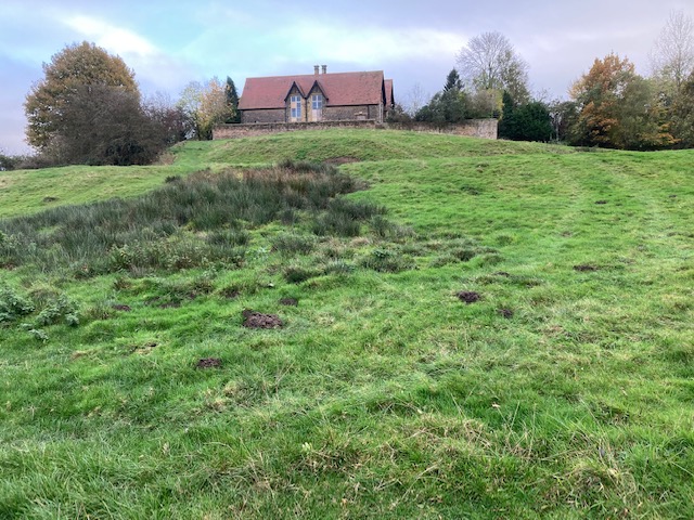
The school sits on the top of the medieval manor house’s site. The area is a scheduled ancient monument.
The building at Stainsby then became what we describe in our book as ‘an imaginative, if short-lived venture’ as a youth music and drama centre. The first warden was a former actor who lived in the headmaster’s house. The Stainsby Arts Centre served schools throughout north-east Derbyshire in the 1960s and early 1970s. From it grew the Stainsby Festival of folk music, which started in 1969 and has long outlived the arts centre.
Now the National Trust is, somewhat controversially, selling the former Stainsby school building by auction. The school board leased the land on which the school was built from the 8th duke of Devonshire. The freehold therefore passed to the National Trust with the rest of the Hardwick estate in 1958, after it was accepted by HM Treasury in lieu of death duties payable following the death of the 10th duke in 1950.
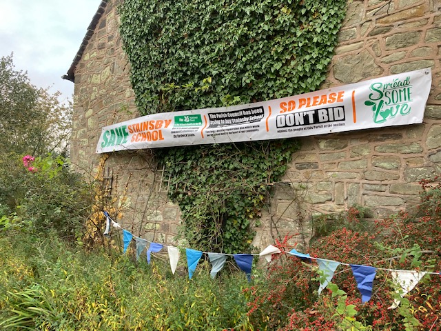
Ault Hucknall Parish Council and a consortium of community groups are trying to purchase the property, but may be outbid in the auction, which ends on 16 November 2021.
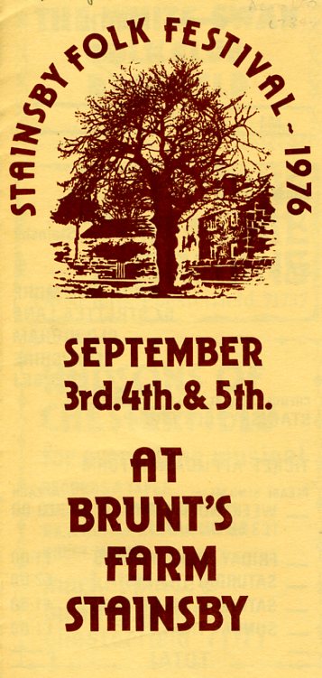
The Stainsby Festival used the old school site, but in 1974 a lessee of the school property did not want the festival. It then moved to nearby Brunt’s Farm. This programme from the 1976 event reveals that weekend tickets to the festival were then £3.00 each. Artists included Broadside, John Goodluck and Threefold. There were also workshops.
Visitors to the site will find of parts of it adorned with bunting, a banner and notices protesting at the National Trust’s decision to sell the property and urging potential bidders not to bid against the community‘s bid for the property.
To end our short series on jam and preserves manufacturing we’re looking at a very small, basically one-man business, in Brimington, near Chesterfield. We’ll also look at how VCH doesn’t replace locally produced histories.
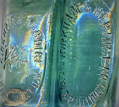
Two Kirkham & Hebdige bottles, that would have been filled with mineral water at their Coronation Road, Brimington premises. The ‘K&H’ site was subsequently used by a short-lived jam and preserves manufacturer.
Water and jam
The story starts when land, at the north end of Coronation Road, Brimington was sold to a Frederick Hebdige and Reuban Kirkham in 1903. They erected a small factory and stable on the land and made mineral water there. But by 1919 the property was for sale with the mineral water manufactory out of use. Our photographs shows two bottles from this short-lived affai
The property was sold to a consortium of people. Included were members of the Hicks family (who were grocers). And so the business styled as ‘The Corona Fruit Preserving Company’ started. (There is no connection, incidentally, with the well-known Corona soft drinks company).
William John Piece of Sanforth Street, Newbold, appears to have been the only active partner in the business, excepting another who acted as sole selling agent for the jam.
New buildings were added by the partners and the business was successful for a few years until 1921, when it made a loss. The partnership was dissolved in June 1921, but Pierce decided to take the whole business on. This was ultimately his undoing as in early 1923 he was filing for bankruptcy. There is no mention of the business in production after that date.
The jam factory, as it became known, was the cause of complaints from the parish council. In early in 1922 it was reported that ‘thick clouds of smoke’ were being emitted from the property, causing a nuisance.
No advertisements have ever been found for either the mineral water or the preserve manufactures and they weren’t listed in local trade directories.
You can find out a lot more about these two short-lived businesses in an article published by the Brimington and Tapton Local History Group – look for the Brimington and Tapton Miscellany 1 download – it’s contained in there.
Replacing history?
Our thanks to Brimington and Tapton Local History Group for pointing out this very small-scale business.
It’s certainly on a different scale to the previous preserves businesses we have looked at. Like the other two, though, it will certainly get a mention in our VCH Red Books.
But the VCH account won’t replace individual histories like that about the Brimington business. VCH can’t hope to go into the detail that individual accounts like that can. But what we will do is ‘signpost’ such accounts in our very thorough references.
We always look at reliable published sources, but will also examine original sources in our parish histories. We’ll undertake research that might well be beyond the average interested person. For example, trips to the National Archives in London can be very expensive and not everyone can read Latin.
If you’d like to find out more about us and how you might help in research please contact us. (And you don’t have to read Latin to get involved!)