Webmaster, Derbyshire VCH Trust

A brief look at Chesterfield Grammar School

We are taking a brief look at Chesterfield Grammar School in this blog. With the school closing in 1991, quite a few people might not realise that Chesterfield actually did have such a school.

Surprisingly few photographs of the old Chesterfield Grammar School, on Sheffield Road, appear in the public domain – at least those of the actual school, as opposed to pupil and teacher school year photographs. Our first illustration is taken from Ford’s 1839 ‘History of Chesterfield’. It shows the second school building on Sheffield Road.

The second grammar school building on Sheffield Road, from Ford’s 1839 ‘History of Chesterfield’.

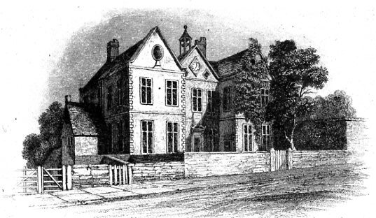
The grammar school was endowed by Godfrey Foljambe of Walton Hall, who died in 1595. The school probably opened in 1598, when it took over the former St Helen’s chapel. In 1710 the medieval chapel was superseded with a two-storey building, shown in our first illustration, which is taken from Ford’s 1839 ‘History of Chesterfield’.  Highly regarded in the early eighteenth century, after some years of decline the school closed in 1832.

The new school opened in 1847.

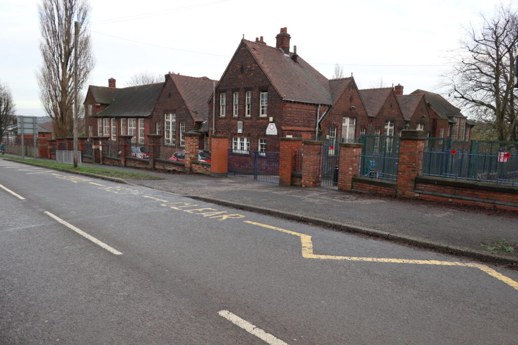
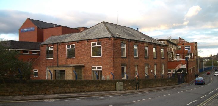
Our second illustration shows the new building constructed, again, near the site of St Helen’s chapel. This new grammar school (boys only and fee paying) opened in 1847. The Rev. Frederick Calder, as headmaster, started a process of expansion and modernisation. This building now forms part of Chesterfield College’s West Studios, which our modern (and third) illustration shows. Part of the 1840s building can be seen, together with a major extension built in 1899 (to the far right). Contrast this with our fourth photograph, which shows the building in an Edwardian colourised postcard.

Chesterfield College’s ‘West Studios’ – the former Chesterfield Grammar School buildings, in 2017.
The main building of the grammar school on Sheffield Road, probabaly in about 1910. The building shown in our second illustration (the 1840s building) is to the far left. (Courtesy Richard Sheppard).

In 1903 the grammar school was recognised as a secondary school. It remained independent until 1940, when it was transferred to Derbyshire County Council.

There were various other extensions to the Sheffield Road site, including the purchase of nearby Hurst House, for use by the sixth form, but the school buildings became increasingly inadequate. A decision was made to relocate to Brookside, where the school’s governors had purchased land for playing fields in 1928. Fully opening in 1967, it’s these buildings that form the basis of the present co-educational Brookfield Community School.

The education ministry’s architect was concerned that this replacement building was itself inadequate in some ways. He was particularly concerned that the kitchen wasn’t large enough, the dining room was ‘critically small’ and that additional windows were needed in the assembly hall to meet Ministry regulations. Nor did he like the combination of steel and pre-cast concrete, or the mixture of brick and small block cladding. The building’s architects were the once well-known Chesterfield practice of Wilcockson & Cutts.

Our final photographs are two taken from a series of postcards of the Sheffield Road site published around 1928, but probably taken earlier. They both show the rear of the building

The school buildings from the south-east.
The school buildings from the north-east. This and the view above are from a set of postcards published in the late 1920s.

The end of, what by that time was called Chesterfield School, came in 1991 following a reorganisation of the town’s secondary schools.

There’s much more about the grammar school and Chesterfield education in general in our VCH county editor’s book ‘A History of Chesterfield Grammar School’. This 700-page book was commissioned by the Old Cestrefeldian Trust, from whom it is available. You can also find out more of the history of the school and a link to purchase the book at http://oldcestrefeldians.org.uk/History.html.

The Old Cestrefeldian Trust is publishing Chesterfield Grammar School Roll of Honour 1939-1945, a 96-page paperback containing short biographies of some 70 former pupils who died while serving in the Armed Forces during the Second World War. More details of this new title will be available nearer the time.

(Our thanks to the Old Cestrefeldians’ Trust for permission reproduce illustrations from their collection and use information from Philip Riden’s book, ‘A History of Chesterfield Grammar School’)

A brief look at Chesterfield Grammar School Read More »

Hulleys of Baslow reach their centenary

North Derbyshire and peak district local bus operator Hulleys of Baslow are celebrating their centenary this year. In this blog we take a look at this operator, whose buses have been a familiar sight in the area for 100 years. VCH covers local bus operators in our red book series (but not the actual fleets in any great detail), as they played an important role in the economy of the area they served and in some cases still do.

Recreation of the old Hulley’s fleet name.

Henry Hulley, who had previously operated taxis, started to run a bus service between Bakewell and Chesterfield in April 1921.

In the following decades routes and journeys increased, with a couple of local operators being purchased before the Second World War. After, there was a fairly brief incursion into the Ashbourne area, courtesy of another business purchase, but these operations were sold in 1954.

Following Henry Hulley’s death in 1971, the remaining family members sold the business in 1978 to JH Wooliscroft & Son, of Darley Dale, who traded as ‘Silver Service’.

A perhaps timeless view of Bakewell in August 1980. The bus on the right is in a red and honey livery adopted by Silver Service after they took over the Hulley operations. It was soon superseded by a blue and honey ‘Silver Service’ livery. The bus is one of a batch of ex Merseyside Leyland Panthers which gave generally unsatisfactory operation with the company.

The familiar red and cream Hulley fleet livery and indeed the name disappeared under the Wooliscroft ownership. But the name reappeared again after the former Hulley’s Baslow garage and routes were sold to the Silver Service Transport Manager Arthur Cotterhill and Peter Eades who was a long-serving ex Hulley employee. The fleet was reinvigorated with a new blue and cream livery adopted.

In 2020 the business was purchased by Alf Crofts, who had been a Hulleys driver for 16 years.

The company held a centenary event at Chatsworth on 26 September where modern buses in recreated old and in current liveries were displayed.

Recreation of two former liveries as displayed at the centenary event held at Chatsworth in September 2021. The left-hand bus is said to recreate the first livery, whilst the right hand bus recreates the Silver Service livery.

At one time Hulleys did have reputation for using quite old vehicles and had some fleet problems. Today the company operates modern buses and once again double-deckers.

There’s lots more information on the history of the company on their website http://www.hulleys-of-baslow.co.uk/hulleys-100-centenary from which some of the information in this post is sourced. A two-part history of Hulleys has recently appeared in the Newsletter of Transpire, the Chesterfield Bus Society.

A 2009 built bus, at the Chatsworth event, which entered the Hulley’s fleet in 2020. This is in the current livery with the company names styled as ‘Hulleys’
It’s a far-cry from this ex-Nottingham bus, seen at Tontine Road, Chesterfield in December 1980. The company, then under Wooliscroft ownership barely seem to have had time to apply a splash of Hulley red – the green and cream being its former owner’s colours!

Hulleys of Baslow reach their centenary Read More »

We’re finding out more about the Foljambes in Chesterfield

DD/FJ/9/1/1 – part of the Foljambe deposit at Nottinghamshire Archives – may not sound very exciting, but some of its contents are helping to fill in gaps in our understanding of the Chesterfield area under that formerly influential family.

The Foljambe Chapel and tombs in Chesterfield Parish Church around 1907 when this photograph was published in JC Cox’s ‘Memorials of old Derbyshire’. Since this date the railings have been removed and the chapel somewhat rearranged.
The Foljambe arms as published in Lysons’ ‘Magna Britannia’ (1817).

Our pictures here show some of the Foljambe tombs in Chesterfield Parish Church along with the family’s arms. The tomb’s grand design and execution show that this was a family of importance in the district up until the early 1600s – perhaps the most influential – with land in Chesterfield and across Derbyshire.

In 1704 Yorkshire antiquary, Dr Nathaniel Johnson compiled a manuscript genealogical history. This chronicled principal Foljambe family members, from the 13th century onwards. It was never fully published, but some copies of the work survive. Now our VCH County Editor and General Editor of the Derbyshire Record Society (DRS), Philip Riden, is working on a new edition of Johnson’s work. Hopefully the DRS will be publishing this in its record series.

As part of this and work for VCH generally Philip is also examining some of the contents of the Foljambe deposit at Nottinghamshire Archives. He’s mainly working on a rent roll of what we believe is for the Henry Foljambe (of Walton) estates in about 1500. It lists purchased lands, not what he inherited, showing what he added to the estate, but not his income. It covers, in particular, property in Chesterfield town centre and surrounding townships.

Although the rental may be incomplete and is in a mixture of English and Latin (warranting careful transcription) it is extending our knowledge of the area. For example, land at Dry Hurst in Tapton is mentioned (this is now the site of the nursery to the front of Chesterfield Royal Hospital). Land in Chesterfield town centre also features. For local historians some familiar names appear such as Thomas Durant and the Heathcote family.

Tapton place names mentioned include ‘Dobyn Clozh Syk’ (presumably Dobbin Clough, near to Tapton Golf Course) and there’s a reference to ‘Colpyttes butts on the Deyn land …’ in Tapton, which is the earliest reference to coalmining in the township.

There’s well-over 100 entries, mainly relating to property in Chesterfield town centre. A typical entry being; ‘Of Robert Flynt tenant of one burgage at the south end of Bocher Rowe between the said Bocher Rowe and Mercer Rowe bought of William Calall’ This is referring to rows in the Shambles.

In the Chesterfield area, following the death of Godfrey Foljambe in the 1590s, the family entered a period of decline.

You can find out more about the Foljambe of Osberton deposit at Nottinghamshire Archives (and the family) here.

Foljambe tombs as first illustrated in Ford’s 1839 ‘History of Chesterfield’.

And about Sir Godfrey Foljambe here.

We’ll keep you up-to-date with any planned publication of the Foljambe family history.

We’re finding out more about the Foljambes in Chesterfield Read More »

Another brush with The HMI – Shuttlewood school’s early 20th century challenges

Our blog of 14 August covered our use of His/Her Majesty’s Inspectors of Schools (HMI) reports and school log-books in our VCH red books. We used Barlborough school’s 19th and early 20th century brush with the inspectors as an example. But problems weren’t only confined to Barlborough!

When the local education authority took over Bolsover schools in 1903 there was dire overcrowding. This included Shuttlewood, where a temporary timber framed, corrugated iron-clad building was opened in 1905 for older children. It was condemned as ‘an awful affair’ by the HMI. To make matters worse the first headmaster was unable to control the children, who were regarded by HMI as backward and unruly. Only two years after opening the school was declared inefficient.

Despite extensions to the temporary building a permanent structure wasn’t opened until 1927. This building was designed by George Henry Widdows. It’s listed grade II and is now occupied by Brockley Primary School. The buildings illustrated here predate the Widdows school, but are next to it. They are empty and scheduled for demolition.

Part of the Shuttlewood schools complex on Clowne Road. This block is scheduled for demolition, having been empty for some years and surplus to requirements. The present Brockley Primary School is out of picture, to the right.

The first headmaster of the new schools (Henry Thomlinson) instituted such things as formal assembly and dinner, sports days and visits. As our volume III states he ‘sought to make the school a place of beauty’.

At this time Shuttlewood was very much a coal mining community. Thomlinson, recognising his pupils’ academic limitations, concentrated on handicraft, art and music, teaching ‘the children to speak the truth and be kind to animals’.

The HMI were somewhat sympathetic to Thomlinson’s aims, but raised some reservations. These included that some of the slower children (and some of the staff) couldn’t keep up with his ideals.

There’s more about the history of education in the Bolsover area and Shuttlewood schools in our Volume III. Our blog of 10 January charted a brief history of the school buildings.

The various HMI school reports shed a light not only on conditions in schools, teaching and the like, but also standards of discipline and social issues. They perhaps alter the sometimes held traditional view that schools used to teach the ‘three Rs’ in a haven of discipline and compliance.

Another brush with The HMI – Shuttlewood school’s early 20th century challenges Read More »

A brief history of Chesterfield’s markets

In this post we take a very brief look at Chesterfield’s markets.

Changing retail – 1. The Market Place (originally part of the New Market first laid out in the 1190s) pictured on the last day of fish stalls on the open stalls. These businesses transferred to covered accommodation in the re-vamped Market Hall. Stall illumination is provided by tungsten lamps. Boots were yet to move to their new Low Pavement premises, which incorporated the former Greave’s chemist premises. An autumn 1980 view. (Philip Cousins).

The first reference to a market in Chesterfield is in 1165 and the present market place (known throughout the Middle Ages as the New Market) had been built by 1199. This is before the burgesses (inhabitants of the borough with full rights of citizenship) were granted the right in 1204 to hold a Saturday market and an eight-day annual fair.

This area of the churchyard would once have been home to part of the original market in Chesterfield.

The old market place, was situated the north side of the parish church. This became known as the Weekday Market, presumably because a small number of traders stood there on days other than Saturdays. The chartered Saturday market was held in the present Market Place. The old market place had been built over the by the 15th century and may have gone out of use before then.

Construction of the New Market of the 1190s, by the Crown Officials who had charge of the Manor of Chesterfield, was undoubtedly a bold move. The existing market next to the parish church must have become constrained due to its position – being unable to be extended.

Changing retail – 2. Low Pavement under redevelopment for ‘The Pavements’ shopping centre in June 1980. The former well-known Greave’s chemist shop was situated in the corner white-painted building. Only the frontages of the original buildings remained after the redevelopment, which comprised a modern shopping complex behind the facades. (Philip Cousins).

The New Market had three components: the open market place (basically the current market area), the lines of shops and houses along its northern and southern sides, and the block of shambles at its eastern end. The shambles were constructed for butchers, fishmongers and possibly other traders who would have stood in the market every day, not merely on Saturdays. The map extract from Potter’s 1803 plan of the town shows some of the layout of the market place area (note though, that not all properties are shown).

The Market Hall, originally built by a private company, dates from 1857. It replaced earlier buildings on the same site. These also provided covered accommodation for some traders and rooms for public meetings. The Market Hall was refurbished in the late 1970s, and again more recently.

Changing retail – 3. Another June 1980 view, this time showing The Shambles under refurbishment. By this time the area had become quite run-down. This photograph would have been taken on a Sunday – before shops were allowed to open in 1994. Note the dog outside ‘Ye Royal Oak’ and the Bass Charrington ‘toby jug’ light above the entrance. (Philip Cousins).

An extract from Peter Potter’s 1803 map of Chesterfield. Not all properties are shown. Note the buildings on the site of the present Market Hall.

Although other fairs were established in Chesterfield after 1204, alongside the main September fair, no additional markets were chartered. The practice of holding markets on Friday and Monday, as well as Saturday, appears to date only from the early 20th century. The practice of erecting stalls other than in the Market Place is much more recent.

In 1900 the livestock market, which had been held in the Market Place, was transferred to a new purposely laid out ste off Markham Road.

One important lesson that can be reached from the market’s long history is that retailing (including markets) evolves continuously and must alter, as it has in the past, to meet changing consumer demand.

You can find out lots more about the growth of Chesterfield town centre and the history of the town’s markets in our ‘Chesterfield Streets and Houses book’.

The above is an edited extract from Chesterfield & District Civic Society’s response to the borough council’s Market Place consultation (http://www.chesterfieldcivicsociety.org.uk/2021/08/chesterfield-market-place-consultation/). It was written by our VCH County editor – Philip Riden – in his role as Chairman of the society.

A brief history of Chesterfield’s markets Read More »

New book on the Chesterfield Brewery Company

The front cover of John Hirst’s new book on the Chesterfield Brewery Company.

We are pleased to welcome Chesterfield pub and brewery historian John Hirst’s new book on the Chesterfield Brewery Company.

Whilst VCH seeks to chronicle local communities, including breweries and public houses, it is not designed to replace research like that by John. In fact, we have used some of John’s previous research, published in his 2005 book ‘Chesterfield pubs …’, in our VCH spin-off ‘Chesterfield Streets and Houses’.

John’s new 28-page book, ‘The Chesterfield Brewery – the story of Chesterfield’s second largest brewery’, chronicles its rise and fall. Also included is information on some of the directors, including the Mills and Burkitt families. There’s a map and plan, list of the brewery’s pubs and photographs.

The brewery, which opened in 1854, occupied a site at the junction of Brimington Road, Brewery Street and Infirmary Road. The Trebor factory occupied the site until recent years, incorporating some of the brewery buildings. It’s now part of the Riverside development, with new offices currently under construction on a part of the site.

John charts how the brewery company acquired the wine, spirit and mineral water business of TP Wood, High Street, Chesterfield (and producer of a locally famous almanac) in 1911. But the end of the 1920s and into the early 1930s saw a decline in the company. This was despite 1920s investment in some grandiose public house schemes. These included the Hollingwood Hotel, Poolsbrook Hotel, Spital Hotel and the Gardeners Arms (all Chesterfield area) and the White Post at Farnsfield.

In late 1934 the Mansfield Brewery Company took over the Chesterfield brewery and promptly closed it down in January of the following year. 

You can read more of the story in John’s book, which is available by emailing him at j-hirst@sky.com. The cost is £4 plus postage. it’s also available from Chesterfield tourist information centre or the Chesterfield museum.

A 1982 photograph from John’s book showing the former brewery premises – then in use by Trebor. Infirmary Road is to the bottom.  The original brewery buildings were centred around the tall chimney. (John Hirst).
John’s book describes the brewery in detail and includes a plan of it. Here in 2004 we see a view of the basement which ‘…stretched beneath the tun room, stables and wagon shed. The tun room was set on cast iron columns and girders, with brick arches …’  Note that the slight curvature of the columns in this photograph is due to the camera lens! When this photograph was taken this area was being used an electric motor store for the Trebor Bassett undertaking. (Courtesy Ian Atkinson).
Another 2004 basement photograph – showing the then plumber’s store. The brick arch construction can be seen. (Courtesy Ian Atkinson).
The soon to be demolished Chesterfield Brewery Company’s ‘Station Hotel’, near the Chesterfield Midland Railway station, as it appeared in TP Wood’s Almanac for 1934. By the end of that year the Mansfield Brewery Company had taken over the Chesterfield company, the brewery soon closing in January 1935. As John Hirst explains in his book, there were a hundred or so Chesterfield brewery pubs, spread over a large area, when they were taken over by the Mansfield concern in late 1934. As our ‘Chesterfield Streets and Houses’ book explains the Station Hotel was first opened in 1877.
Another illustration from John’s book, this time reproducing an advertisement from ‘Commercial Chesterfield’ of 1931. TP Wood’s High Street premises, over-looing the Market Place were sadly demolished in the mid-1960s to make way for the Littlewood’s (now Primark) store.
The Chesterfield Brewery premises included this building which was used for the brewery manager and for company offices. The building later formed offices for the Trebor sweets factory. Now demolished, a new office block is currently being built on the site. A 2004 photograph.  (Courtesy Ian Atkinson).
A final image from John’s book – ceramic match strikers like this would have found a place on Chesterfield Brewery Company public house bars. Matches went in the top and were struck on the base. Despite the ‘noted ales’ slogan, the brewery’s ales were apparently regarded as poor quality in its latter years.

This blog was revised on 27 August 2021 to correct the date TP Wood’s business was acquired by the Chesterfield Brewery Company (in 1911 not the previously stated 1921) and to correct a minor typographical error.

New book on the Chesterfield Brewery Company Read More »

Harsh comments for Barlborough School in the 19th century

We make extensive use of school inspectors reports and school log books in our VCH ‘Red Books’ as we plot the history of education in a particular parish. Here we look briefly a Barlborough, where some of the comments made by the Her Majesty’s Inspectors of Schools in the late 19th century were quite severe.

Barlborough Schools in 2021.

With only a few exceptions, the inspectors made uniformly poor reports. For example in 1876 they found the school was unpopular with parents and numbers on role had decreased. Early in the 20th century the inspectors found the schoolroom was dirty with a lack of separate classrooms. One of the problems appears to have been with the headmaster’s attitude and lack of staff. In 1898 an assistant was teaching 55 boys, with the headmaster only 18, both in the same room.

The school was transferred to the county education department in 1903. A new headmaster – David Barnfield – appointed two years later found the school in an ‘indescribable’ state with poor discipline and low standards of work. It was he who helped turn the school around. He was there for over 30-years – the school receiving excellent reports throughout.

The premises are pictured here in 2021. Part of the buildings probabaly date back to 1866, when they were originally erected by the Rodes estate. They were extended in 1911, with further new classrooms added in 2000 and 2002. For some time, the memorial gateway we featured in our recent post formed an entrance to the buildings.

Our VCH Derbyshire Volume III – Bolsover and adjoining parishes tells the fuller story of education in Barlborough.

Harsh comments for Barlborough School in the 19th century Read More »

A Chesterfield Mystery: ‘The Pump House’

This June 1985 view of Chesterfield taken from the parish church tower shows a familiar, if changed, view. But it’s not the by-pass under construction snaking away to the top left, the now demolished Trebor (once the Chesterfield Brewery Company) premises (left of centre) or the soon to be demolished Chesterfield Hotel just behind the tower to the Stephenson Memorial Hall (right), that we are discussing in this post, but a rather more elusive building ‘The Pump House’. 

As the map extract from our Chesterfield Streets and Houses book shows, this mysterious property sat in the area to the right of Tapton Lane – which can be seen travelling down out of town, to the bottom centre of the photograph. 

This map extract from our Chesterfield Streets and Houses book, shows the approximate position of a mysterious Chesterfield property – ‘The Pump House’.

The house appears to have been built by a Marmaduke Carver (d. 1756).  It’s not shown on William Senior’s 1633 survey of Chesterfield. Joseph Hunter mentions this house by name in his book Familiae Minorium Gentium (‘Families of the Lesser Gentry’). This may be the only place the name appears! 

Marmaduke Carver married Ann Milward. One of their offspring – another Marmaduke – was town clerk of Chesterfield from 1711 to 1745. The house and its estate were then owned by other members of the Carver family (for the full story see Streets and Houses), until the estate was sold by John Carver in 1804, for £2,100, to Robert Malkin – a wholesale grocer of Chesterfield, who was already living there. This is where Malkin Street gets its name from. In 1833 Malkin purchased, from the Cavendish estate, a plot of land on the south and east sides of his house, at the top of Tapton Lane. This land was already occupied by him as a pleasure ground.

Malkin died in 1846. Two years later his daughter sold the house contents and the house was advertised to let in 1858. The following year the property was sold to John Marsden, also a Chesterfield grocer. He sold the house and some of the estate to Chesterfield corporation in 1870, when the house was demolished and Corporation Street was laid out through the grounds.

The Malkins were members of the Unitarian congregation at Elder Yard meeting house and were known for their benefactions to the poor in Chesterfield.

One mystery remains and that’s around the name ‘The Pump House’. Surviving deeds do not mention it by name, nor do various maps and surveys. Why the reference to a pump?

An extract from a 1966 tracing of Ward’s 1854 map of Chesterfield. The near-rectangular piece of land, slightly right of centre, was presumably part of the pleasure grounds to ‘The Pump House’.

Unfortunately, although the house is shown on large-scale maps, no illustration of ‘The Pump House’ is known to exist. Oddly enough, there is a watercolour sketch of the church from the north made in 1824, when there were still houses standing in what is now the northern part of the churchyard, entitled ‘Chesterfield from Mr Malkin’s’, but the artist must have been sitting in the gateway to the house, with his back to it. The drawing was reproduced some years ago in the booklet, Chesterfield: Scenes from Yesterday.

A Chesterfield Mystery: ‘The Pump House’ Read More »

How your place got its name

Local historians are often asked what a particular place-name means and where it’s come from. In VCH we use the standard reference work on the subject, the multi-volumed English Place-Name Society (EPNS) volumes.

As the society’s website explains EPNS;

… was established in 1923 to conduct a county-by-county survey of the place-names of England. The first county survey of Buckinghamshire appeared in 1925.

To date, the Survey has produced 91 volumes, the most recent being The Place-Names of Leicestershire Part VII, published in 2016. Almost all English counties have been surveyed at least in part and work to complete the Survey is ongoing.

The Survey is used by researchers, academics, and those interested in the origins, meaning, and significance of English place-names.

The gold standard form place-name study – the multi-volume English Place Name Society books.

Derbyshire has a complete survey, split across three parts. Part one includes a general introduction, survey of river names and covers the High Peak Hundred. Part two covers the Scarsdale, Wirksworth and Morleyston & Litchurch hundreds; part three the Appletree, Repton & Gresley hundreds with analysis and indexes. Despite being published in 1959, the volumes are still the ‘gold standard’ for place name study. There’s an entry for each place studied which consists of a list of names associated with it, followed by a description of the name’s meaning. Street names and field names are also identified – with some more notable ones being very briefly discussed.

So, as an example; for Chesterfield, (which is in part two) the survey identifies the name ‘Cestrafelda’ as being used in 955 and other variations thereafter, declaring the name means ‘open country near or belonging to a fortification’. At time the survey was published in 1959, existence of a fort in Chesterfield was still unproved, but we now know that indeed the town was a Roman fort.

You’ll need access to part one to identify what some of the abbreviations in the text for each place-name mean. Incidentally the ‘maps’ identified on the dust jacket of part one are actually in part three!

Some of the society’s publications (but not currently Derbyshire) are now available on-line  https://www.nottingham.ac.uk/research/groups/epns/downloads.aspx. The Derbyshire volumes are now out-of-print, but you may be able to obtain second-hand copies. They are also available to consult in Derbyshire and Derby Libraries local studies.

Despite its age The Place-Names of Derbyshire is VCH’s first port-of-call when we look at place-name origins. It ought to be yours too, if you are interested in the subject of how your community came to have its name.

How your place got its name Read More »

Mustering up some family history sources

Our sister organisation – the Derbyshire Record Society – is just about to publish part one of The Derbyshire Musters of 1638–9. This part contains the introduction and indexes. We explore a little about this book in our blog, but it will be an important contribution to the history of the county and of great use to family historians. ‘The Muster book’, as it has become known, lists all men aged between 16 and 60 in each town and village.

Between the early sixteenth century and the mid seventeenth the Privy Council instructed local officials in each county to hold regular musters of able-bodied men who could be called upon to defend the kingdom in time of war. Men from every town and village had to assemble, usually in the early autumn, at a specified meeting place and show that they possessed suitable arms and armour. Gentry families had to provide horsemen. The musters were ordered by the lord lieutenant, summoned by the deputy lieutenants, and organised locally by the high constable of each hundred.

In 1638 the young 3rd earl of Devonshire had just become lord lieutenant of Derbyshire. He was evidently keen to impress the Council, as the earl ordered the constables to compile lists of all men aged between 16 and 60 in each town and village. He had the results copied into a volume to be sent up to London. The book, containing some 17,300 names, survives among the records of the State Paper Office in The National Archives. It provides a uniquely full record of the inhabitants of every community in Derbyshire on the eve of the Civil War. What we don’t know, of course, is what these men thought of being brought together, their names and place of residence being identified and listed.

The new publication should be fantastic source for family history in Derbyshire, as well as the demography of the county. It also sheds new light on local administration in the early seventeenth century.

In this two-part edition, the text of the 1638 muster book is printed in full alongside a shorter roll of 1639 and some ancillary documents (as part 2 – available in the autumn of 2021). In all about 18,400 individuals are named. Newly published Part 1 consists of a full index by person and place and is prefaced by a detailed introduction.  The record society has divided the book into two parts so that users can have the index and the lists of names in front of them at the same time. It also spreads the cost of a work that runs to over 400 pages.

To order new title you can complete the online order form here.

The Derbyshire Musters of 1638–9 (in two parts) is edited by Victor A. Rosewarne. Part 1 is £20 post free to members or £30 plus £3 postage to non-members.

Mustering up some family history sources Read More »