No apologies for advertising our nee Hasland book’s launch on 15 June, in this blog.
Pop along to see us at the Devonshire Arms, Hasland, starting at 7.30pm. There’s no admission fee and you’ll be able to hear our county editor Philip Riden, give a short account of the book and the formerly extensive parish of Hasland. You’ll also be able to purchase the book if you want to.
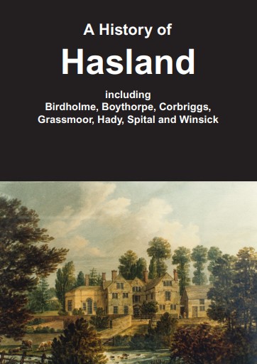
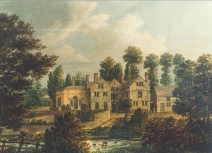
Our Hasland book cover, by kind permission of Derbyshire County Council, features Spital House. Our last blog looked at this now disappeared property.
Published on behalf of the Derbyshire Victoria County (VCH) Trust, the book represents hours of research by a group of volunteers, under the guidance of VCH county editor Philip Riden. They have been busy researching the history of Chesterfield for around 20 years. Although this is the second publication as a result of this work, it is the first to look at an actual area of Chesterfield and the north eastern part of the county – and more are set to follow.
The book looks at Hasland’s history through the ages, charting the many communities that once made up its historic area – Spital, Hady, Boythorpe, Grassmoor, Winsick, Birdholme and Corbriggs. The beginnings of the township, its growth, economic history, religion, education, landownership and local government are amongst topics covered. Large-scale industry like the former Chesterfield Tube Works gets a mention, along with the less well-known story of local mining, the Broad Oaks furnaces near Storforth Lane and many others.
Philip Riden described the history as the fullest account of the history of Hasland published so far, and the first ever attempt to write the history of Grassmoor or Birdholme. He commented; ‘Our work on Hasland was well progressed, and so we thought there was a need to bring this together and publish it. Hopefully, local people will find the book of interest. It’s really an interim account of the township as we aim to produce a volume of the Victoria County History for the area.’
At some 200 pages with colour illustrations and maps, the A4 sized hardback book will be available to purchase at the launch and afterwards at Waterstones in Chesterfield and the town’s Visitor Centre and from the publisher Merton Priory Press (mertonpriory.co.uk). It’s priced at £20 (plus postage and packaging).
Philip Riden comments; ‘We hope that by publishing our research it will herald a new understanding of the area’s varied past. All VCH accounts are well-researched, fully indexed and have copious references, so that anyone interested can look up our sources and research things further if they want to’.
The Trust’s first publication in this spin-off series, Chesterfield’s Streets and Houses, is still available. The next spin-off book will be an account of Temple Normanton and Calow.
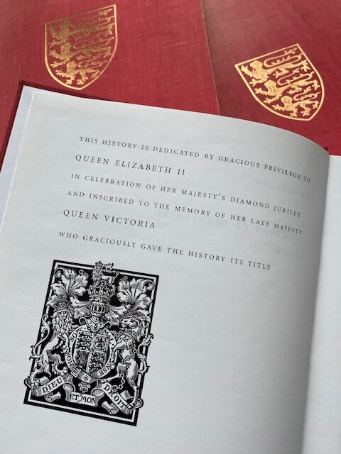
Our colleagues at our VCH central office at the Institute of Historical Research remind us that Royal Jubilees have a special place in the history of our project. The Victoria County History was dedicated to Queen Victoria and was intended as a lasting celebration of her Diamond Jubilee in 1897. On Elizabeth’s Diamond Jubilee, in 2012, that royal dedication was renewed.
In 2013 we published our first big red book since 1905 and 1907. Our 2013 book was amongst the first to carry our revised dedication to Her Majesty in her then diamond jubilee year.
Congratulations to Her Majesty on her Platinum Jubilee.
Our book on the history of Hasland features Spital House on its front cover. The property is now disappeared, though there are some remnants. We take a brief look at the property in this blog.
Our Hasland book’s front coverfeatures Spital House.
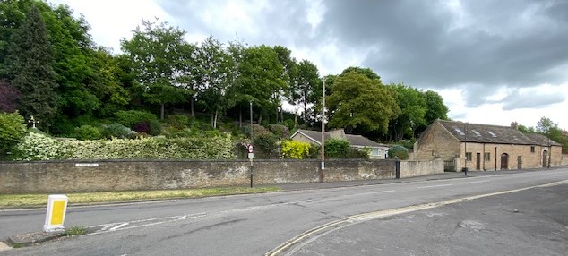
Spital House stood on the east side of Spital Lane about midway between the junctions with Hady Hill and Calow Lane (opposite the present Co-op).
Early ownership
It appears to have formed part of the Foljambe family’s estate centred on Walton Hall, although when they acquired this part of their property is not clear. It passed to their successor, Sir Paul Jenkinson Bt, who married into the Revell family. It then fell to Richard Turbutt of Doncaster, to the Babington family and to John Woodyeare.
Among the larger houses in 1670 were those of Mr Shawe senior, Mr Shawe of Spittle, Mr Wheeldon and Mr Jenkinson of Spital. The property is likely to have been one of these.
The site of Spital House on Spital Lane is approximately where the modern bungalow, to the centre of this photograph, is sited.
The 19th century
We’ll fast-forward into the 19th century, but there’s more about the intervening history in our book.
In 1801 John Woodyeare included Spital House, together with about 100 acres of land adjoining and 22 acres at Grassmoor, in a sale of portions of the Walton Hall estate. Neither Spital House nor most of the land was sold. When a further attempt was made to dispose of the estate in 1812, after Woodyeare’s death, the sale included Spital House and 75 acres of land in Spital and Hasland. Spital House was described as ‘calculated for the residence of a very respectable gentleman’. It was not as big as Walton Hall, the main mansion on the estate.
A closer look at our book’s front cover. It’s a water-colour of Spital House, painted about 1813 – reproduced by courtesy of Derbyshire County Council.
In 1813 a sale by private treaty was agreed with Sir Thomas Windsor Hunloke of Wingerworth Hall of the entire Woodyeare estate. In 1821 part of this estate, including Spital House and some adjoining land, were offered for sale by order of the court of Chancery during an action involving the trustees of Sir Windsor Hunloke’s will.
It may have been John Charge, the Chesterfield attorney who was also clerk of the peace for the county and practised from 23 West Bars who bought the Spital House estate from the Hunloke trustees in about 1821.
Charge died in 1849; his widow in 1850. Elizabeth left her property to be divided between her nephews and nieces, the children of her sister Jane. The Spital House estate passed to the Revd John Boyer, who was living there by the start of 1852 but later moved. On her death John’s wife left £1,000 to meet the cost of building new almshouses on Saltergate to replace those in the parish churchyard.
Edwin Mason, the head of the firm of George Mason & Son, the tobacco manufacturing business founded by his father, with works at Spital, was the next owner. Mason also bought all the land in front of the house through to Mansfield Road. He died in 1887, aged 58, after which his two sons lived there at varying dates.
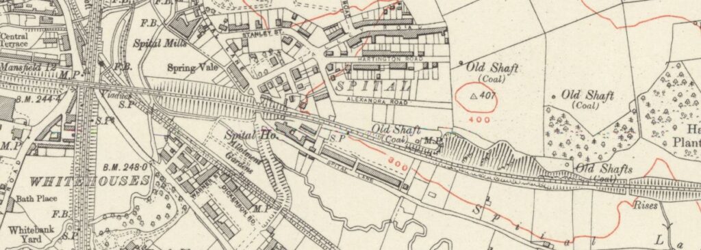
Spital House and the surrounding area from the 6″ Ordnance Survey map. The Lancashire, Derbyshire and East Coast Railway is the line running roughly left to right across the map. (Derbyshire Sheet XXV, revised: 1914, published: 1921. Courtesy National Library of Scotland – https://maps.nls.uk/)
Enter the railway
In 1892 it was announced that the Lancashire, Derbyshire & East Coast Railway was to run immediately behind the house. By March 1893 the railway company had purchased Spital House
The LD&ECR’s general manager, Harry Wilmott, lived at Spital House until the company was absorbed into the Great Central (as the MS&LR had become) in 1907. That year the new owners sold 52 acres of 25 accommodation and building land belonging to the Spital House estate, described as suitable for either house-building or works that required railway access.
By 1912 Spital House itself had been let to John Morton Clayton, one of the principals of Joseph Clayton & Co. Ltd, whose tannery was nearby on Clayton Street. Clayton left or a few years later.
Spital House was taken over by an Anglican order of nuns, the Sisters of the Poor, who were resident there by 1921, when it was proposed to build the Spital Hotel opposite. They vacated in 1932, when the property was advertised to let as either a private house or ‘dancing rooms’.
Decline
Spital House was briefly used as a kindergarten and preparatory school run by Mrs Annie Dixon, previously of 79 Saltergate. After this closed, the property became a lodging house. An inspection in February 1936 discovered eleven tenants living there, seven in conditions of overcrowding which were unlawful under the 1935 Public Health Act.
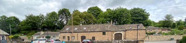
Spital House was to the left in this recent view of the area. The coach house to the property is to the centre and has been restored as a residential property.
During the Second World War Spital House was used by Chesterfield corporation for storage, but when this ended the property was taken over by squatters. In March 1950 the Railway Executive (as owners of the freehold in succession to the Great Central and LNER) had the squatters removed. The following month the Executive was reported to be demolishing the building, described as dangerous and lacking water or sanitation, at the request of the local authority.
What did Spital House look like?
The watercolour painting, on the front of our book, is said to date from c.1813. It shows the main (west) front from the opposite bank of Spital brook, appears
It was an E- plan house of two storeys and attics, built of local coal measures sandstone, with stone-flagged roofs. There were brick-built chimney stacks at the north end and towards the southern end of the main range, and in each of the wings. On the ground floor the central doorway had a pedimented surround. The windows appear originally all to be have been two- or three-light mullioned windows with hood-moulds over, although by the early 19th century some had been replaced with sash windows. These features (except perhaps the chimney stacks, which may have been altered) appear to be consistent with an early 17th-century date of construction.
By c.1813a single-storey extension had been built on the north end of the original house which was enlarged by the early 20th century – upwards. A two-storey bay had been built in the internal angle between the north side of the north wing and the extension.
In the garden to the rear of the house, the painting on our book’s cover shows what appears to be a small ‘temple’ with a pediment supported on four arches. This would have disappeared when the LD&ECR line was built through the grounds, if not before.
Immediately to the south of the house stood a long, low building which appears to have been a stable block. This was not demolished in 1950. It was sold in 1984 and converted into a private residence. Other outbuildings further south again remained derelict at the time of writing, as they had done for many years, although a boundary wall was rebuilt in 2020–1. The buildings presumably date from the late 17th century or early 18th. A mounting block on the pavement outside the stables has been jumped off by generations of small children.
Some years after Spital House was demolished, a bungalow was built on the site, set in a precipitous garden created from part of the LD&ECR embankment.
Find out more about our book on the History of Hasland here.
Sources used in this blog are fully referenced in our ‘History of Hasland …’ book. Though it is now out of print copies should be available in Chesterfield local studies library.
This post was originally devised to help publicise the publication of our now out of print book on Hasland. It was edited on 4 April 2024 to remove references to the book’s forthcoming publication.
In this blog we’ll look at one of the unfortunate but less obvious results of the demise of Eyres of Chesterfield – the disappearance of its company history on their now removed website. But thanks to the Internet Archive at least part of the site has been preserved.
This isn’t to detract from the problems and hardship that are caused to employees and customers of a company that reaches the end of the road – these cannot be underestimated.
Pre internet days – front page of a brochure published in 1925 to mark 50 years of Eyre & Sons Ltd. In fact it’s fairly brief on the company’s history – this is all you get in the 75-page brochure. The rest mainly features available products including pianos and gramophone record players along with the more traditional bedroom and living room furniture. Note what latter became the Stephenson Arcade – then Eyre’s Arcade on Stephenson Place. At this time the company were also involved in furniture removal, and decorating. The brochure’s front cover was also keen to promote their ability to furnish hotels and undertake bar fitting.
Missing – presumed lost. Part of the now disappeared Eyres of Chesterfield website. The summary history text may have been preserved by the Internet Archive.
It’s a fact that many companies now publish the only readily accessible history of their business on their website. Largely gone are the days when companies used to produce hard copy product brochures which might contain a useful potted company history.
Eyres was a longstanding and formerly prosperous Chesterfield company. Latterly it had been situated in large retail premises on Holywell Street and Stephenson Place, in the centre of the town. According to the company’s own website – now disappeared following announcement on 20 April 2022 that it had ceased trading – it was first founded in 1875. An Isaac Eyre of Barrow Hill, near Chesterfield, ‘was left jobless, and needed to find another way of earning income to raise his family.’ He started out buying and selling sewing machines and mangles – ‘Victorian Eyres was born’.
The enterprise grew into his first premises at 3 Holywell Street. His son joined Isaac, by which time they were making furniture. (There was a substantial cabinet making factory at one time on Tapton Lane). 1891 saw the concern move to larger premises – which remained the site of the business until its sad closure. Eyre & Sons Ltd was registered in 1894, in 1897 the website claimed ‘Eyres became the largest Furnishing Store in the Midlands. Their reputation spread so far that people came from miles around to buy their furniture.’
Usefully the former Eyres website gave an out-line of the company’s later history. In the mid-1980s there were 12 stores trading, but in 1985 most of these closed down. ‘Charles Summers formed Eyres of Chesterfield in his great Grandfather’s original premises.’ Charles became a member of the Worshipful Company of Furniture Markers – a City of London liovery company – in 2019.
The now removed company website also contained some historic and modern photographs and the usual run-down of products sold, along with information about the ‘Artisan Café’ and the store’s gift department. All of this has now disappeared, though some of the photographs can still be found elsewhere on the web.
In Worksop and Mansfield the Eyres business has been completely separate since the mid-1980s. The Eyres of Worksop website fills in some of the details.
There was a 6 week break in trading in 1985 when all Eyres stores were sold to a property company but soon enough a new company, Eyres of Worksop, was formed and leased the building from the property company. The present company has continued to run for the past 30 years and the building itself was bought in 1991. So one way or another, with only two small hiccups, Eyres have provided an excellent service with a vast selection of goods and aim to do so well into this century.
The Companies House website (which contains information on companies, such as accounts and incorporation documents) shows that Eyres of Chesterfield had been formed as Chaselodge Ltd at the end of December 1984. But Chaselodge had almost immediately changed their name to Eyres of Chesterfield Ltd.
You can search for the Eyres’ former website and view it (and other ‘disappeared’ ones) on the Internet Archive, but depending on which browser used the illustrations may not be present and the original layout may not have been preserved.
Another extract from the 1925 brochure. The middle photograph is of the ‘magnificent carpet saloon’ A recent newspaper report stated that this was a former chapel. It was not, though as we have previously written, a former medieval wayside chapel was not far away, but this disappeared many years previously.
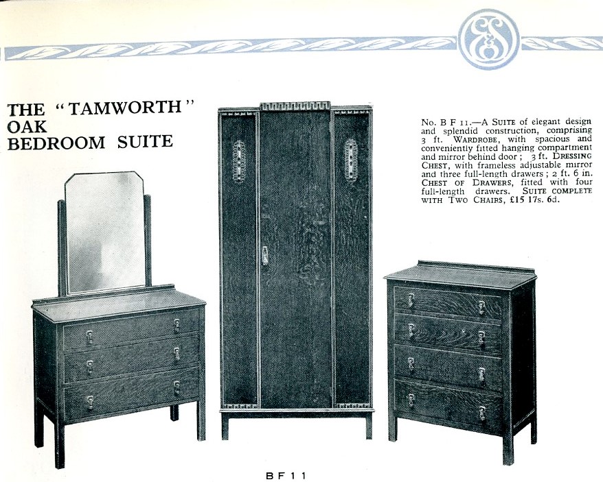
Our final extract from the 1925 brochure shows this bedroom suite. This may well have been made at Eyre’s own cabinet factory – a large corrugated iron clad building at the bottom of Tapton Lane. Eyres also owned Ryland Works – a trade wholesalers with premises latterly off Newbold Road. These premises replaced a building off Stephenson Place, which had had its top storey gutted by fire many years ago. In the 1970s the surviving ground floor was used as Eyre’s second hand furniture shop.
This post was edited on 22 May 2022 to add reference to the Internet Archive.
Our new Hasland VCH spin-off book is to be published at a launch event on the evening of 15 June at the Devonshire Arms, Hasland.
The book will be the first authoritative account of this large parish.
Until 19th-century boundary changes, the township (later civil parish) of Hasland (near Chesterfield) included not just what people think of as Hasland today but also Corbriggs and Winsick, Grassmoor, Birdholme and the St Augustine’s end of Boythorpe. It formerly included much industry on Derby Road. We’ve recently been featuring some of the many varied subjects covered in the book in our blog. You can rad more about why Hasland has been chosen for our first township based spin-off book in our blog.
With colour plates, of just over 200 pages, A4 in size, we think that this will be a landmark publication in the history of the area. The book will be available for £20 at the meeting. We also hope to make it available in Waterstones bookshop in Chesterfield and by post from the publisher (additional postage of £5 will apply).
The launch event, which is free to attend, will be held on Wednesday 15th June starting at 7.30pm in the function room at the Devonshire Arms, Hasland. To find out more about the launch event visit our events page.
The final part of our concise overview of the Chesterfield tube works is presented in this blog. It’s an edited version from our forthcoming VCH spin-off book on Hasland, with some new information added about the concern’s more recent years.
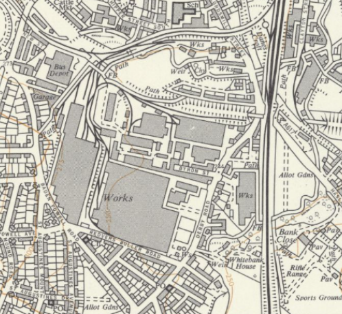
This 1950s map shows the tube works facility on either side of Derby Road. In 1956 the works occupied over 16 acres on a site of 36 acres. The premises towards the top (northwards) of Byron Street are that of Bryan Donkin & Company. (Ordnance Survey , 6-inces to 1 mile, sheet SK37SE – A, 1968.Reproduced with the permission of the National Library of Scotland, National Library of Scotland – Map Images (nls.uk)).
The1950s saw a programme of programme of modernisation and expansion. In 1950 a new factory to make small cylinders from steel tube was opened (the Alma Works). For a time the company was the largest producer of cylinders in the world. A new hot mill for weldless steel cylinders was opened in 1955.
In 1956 the works occupied over 16 acres on a site of 36 acres. By that date the company had made over 8 million cylinders for compressed and liquid gases for use in shipyards, steel mills, mines, aircraft, hospital and many other locations.
The largest of the presses at the Derby Road plant was installed in the 1960s, remaining in use until the site closed. In these years products included the traditional range of seamless steel cylinders for all kinds of gases, hot- and cold-drawn seamless steel tubes, seamless steel headers for boilers and superheaters, seamless steel water and steam boiler drums and pressure vessels, and stainless steel drawn and extruded tubes.
In 1962 the Tube Works occupied 50 acres, had over 2,000 employees, and produced 2,000 tons of cylinders a month. The works had its own St John Ambulance unit, medical and dental surgeries, and a large sports and social club with its own premises at Bank Close, off Hasland Road. In 1963 the stainless steel businesses of Accles & Pollock and Talbot Stead were amalgamated to form TI Stainless, to which the stainless division at Chesterfield was added in the 1970s.
In 1974 new forging plant was installed at Derby Road for the manufacture of industrial cylinders. The company also made tubes from sterling silver for ICI which were used in photographic processing.
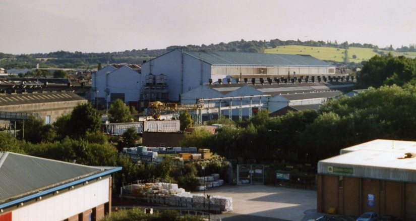
This September 2005 view shows how the large shed-type structures that were part of the Tube Works dominated the Derby Road part of the town. This photo was taken from the top of The Pavements car park.(Courtesy Philip Cousins).
In 1970 the company claimed to be the world’s largest maker of precision steel tubes in sizes up to 660 mm. in diameter for automotive, nuclear and others.
In 1987 the stainless-steel portion of the business, now known as TI Stainless Tubes, was acquired by the Sandvik Group and was renamed Sterling Tubes Ltd. Investment of over £2m. in new plant followed and around this time the company was exporting over 70 per cent of its output. In 1976, 1982 and 1987 the company received the Queen’s Award for Export Achievement.In 2001 Sterling Tubes’ Chesterfield and Walsall manufacturing sites were closed.
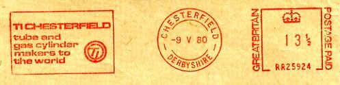
TI Chesterfield’s letter stamp, proudly proclaiming that they were ‘tube and gas cylinder makers to the world’. (Collection Philip Cousins).
1988 saw the remainder of the business, TI Chesterfield, purchased by United Engineering Steels, a joint venture by the British Steel Corporation and the GKN Group, and renamed Chesterfield Cylinders. In 1995 the plant became part of BSC Forgings Division, which two years later was bought by United Engineering Forgings. In 2001 it was taken over by EuroCylinder Systems of Germany who sold the specialised cylinders business to a management buy-out in 2004. The former high volume manufacturing division for standard cylinders appears to have been closed. The surviving company’s name was changed to Chesterfield Special Cylinders (trading as Chesterfield Cylinders). The company had to relocate, achieving this by a move to Meadowhall in mid-2005. Just before the move to the new premises the company updated its logo to CTCO. This resurrected initials first used, it was claimed, in 1927 as a cylinder head stamp, for Chesterfield Tube Company. Housing now covers the entire main entire site, with a leisure park having been built in then late 1990s on the former site of the 1950 new factory (Alma Works).
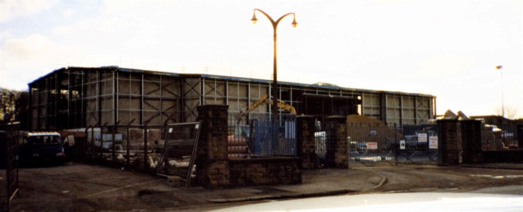
The new Cinema World complex is under construction on the site of the former TI Chesterfield’s Alma works in early 1998. The gates in the foreground and the lamp standard are remnants of the former works entrance. Not only was a manufacturing facility once here, but also a well-equipped apprentice training centre. (Collection Philip Cousins)
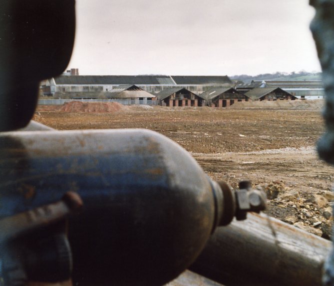
End of an era. Discarded industrial cylinders make a sad sight looking over their probable birth place, then being cleared for housing. An April 2006 view. (Courtesy Philip Cousins).
Please note that the photographs in this blog will not appear in our Hasland book.
The old Hasland parish covers a wide area of Chesterfield, including the once heavily industrialised Derby Road. One of the biggest industrial concerts in the township was the works Chesterfield Cylinders. ‘The tube works’ as they were known is the subject of this blog.
We’ve condensed text from our forthcoming VCH spin-off book on Hasland, to present this shortened history of the companies which once occupied the prominent sites on either side of Derby Road.
An aerial view of Chesterfield Tube Works in 1958, showing its enormous extent by that date. In the background the former Lancashire, Derbyshire & East Coast Railway is disused but the formation remains intact; to the right the former Midland Railway main line passes beneath it. (Courtesy Picture the Past/Derbyshire County Council).
The works are established
The development of land on either side of Derby Road to the south of the town by the engineering industry began in 1897 when Augustus William Byron, a prominent Chesterfield land agent and businessman, promoted the Universal Steel Tubes Company (Ehrhardt’s Process) Ltd to make weldless steel tubes for naval vessels, exploiting the UK rights to a German process.
Chesterfield was chosen for the new venture because of its central position in a traditional iron and steel making district and the availability of fairly cheap labour. An 11-acre site on the west side of Derby Road about half a mile south of the town was acquired, on which buildings covering 3½ acres were erected, known as the Universal Works. There was with rail access via the Brampton branch of the Midland Railway.
In 1899 Byron’s firm announced the sale of freehold building land adjoining the works, noting that arrangements could probably be made with the purchaser to lease 50 houses erected on the land to the Universal company, presumably for workmen and their families.
The original company failed in April 1901. In November that year the business was reconstructed as the Universal Tube Co. Ltd. There was a further reorganisation in 1906, when a syndicate of London financiers, purchased a tube-making patent from a Balfour Frazer McTear, an engineer employed for a time as a manager by the Universal company. The syndicate established the Chesterfield Tube Co. Ltd. The new company took over the existing business as a going concern
Chesterfield Tube remained independent until 1929, when it was absorbed into Tube Investments Ltd, a combine established in 1919 to reorganise the industry.
Products and expansion
The Chesterfield plant was initially equipped with ‘Ehrhardt’ machinery, delivered in September 1898, and also used the Pilger process. The company faced a number of technical problems in its early years, some of which were overcome by extruding the tubes. In this period it produced boiler and economiser tubes for the Admiralty and small tubes for locomotives and other applications. Shell forgings were made during the Boer War. After the reconstruction of 1906 the company, with about a hundred employees, initially concentrated on boiler tubes and other small diameter products but from 1907 expanded to make weldless steel tubes. It also made weldless steel cylinders for oxygen and carbon dioxide.
During the First World War the Chesterfield plant employed about 1,500 men. New forging presses and hot- and cold-draw benches were installed. The company’s contribution to the war effort included aircraft tubing, light oxygen cylinders for aircraft, explosion vessels, torpedo tubes and over 2.5 million shell bodies.
The interwar period
After 1918 pre-war products returned and diversification into new lines, including weldless steel rectangular and square section headers for boiler plants in power stations took place. Progress was made in the manufacture of cylinders for the storage and transport of permanent and liquefiable gases.
After the company became part of Tube Investments in 1929 the Chesterfield works concentrated almost entirely on weldless steel cylinders, tubes and forgings up to 6 in. in diameter. It also pioneered the production of hot- and cold-drawn stainless-steel tubes.
In 1935 the company installed an extrusion press, thus becoming the first commercial extruder of stainless steel in the world and the main supplier of stainless-steel hollows to other companies in the TI combine engaged in cold drawing.
A heavy tube department was established in 1938, equipped with a 5,000-ton vertical hydraulic piercing press, enabling it to produce large stainless and carbon steel tubes up to 24 in. diameter. The works then occupied some 10 acres.
An attempt in 1933, pioneered by the Tube Company and Bryan Donkin, to introduce compressed coal gas as a means of propulsion for cars and lorries was unsuccessful because of the lack of filling stations and the taxation of road vehicles by weight.
The Second World War
During the Second World War Chesterfield Tube produced for the Royal Navy high pressure air vessels and air firing reservoirs, boiler drums for corvettes and frigates, heavy forgings for shells and more than 6,000 torpedo air vessel bodies. More than 4,000 tons of the company’s seamless steel steam pipes could be found in almost every ship the Navy launched during the war and afterwards. The small tube department’s contribution included over 12 million feet of aircraft tubing, including tubes for the Rolls-Royce Merlin engine and for fuselage spars, as well as tank axles for the Army and munitions for all three Services.
In 1941 the company occupied 29 acres on Derby Road, including 13 acres of workshops. After the war the company continued to concentrate on stainless steel tubes, almost all of which went to two other TI companies for cold reducing or cold drawing to smaller sizes.
We’ll continue our brief overview of what was by now TI in our next scheduled blog. You’ll be able to read a much fuller history of the site in our Hasland book, due out in June 2022).
A pioneer school for ‘delicate children’, home to Chesterfield’s richest woman, built by Chesterfield entrepreneur TP Wood, hospital annexe and now a school and home to model railways. Brambling House at Hady, just within the old parish of Hasland, certainly has an interesting history which we explore in this blog.
Brambling House, April 2019.
Our spin-off book on Hasland will give a concise account on Brambling House, which is situated towards the top of Hady Hill, Chesterfield. (Historically it was just inside the large parish of Hasland). But our account will be fairly concise, as with all such VCH accounts. But you’ll find it has been meticulously researched. This means anyone who wants to add to the story can do so, aided by the full footnotes. Here we’ll trace Brambling House, with the aid of text in our Hasland book, but with a little more added history and photographs and minus the footnotes.
Brambling House is built
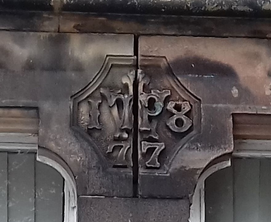
This carved datestone is set above one of the ground-floor windows. TW – is for TP Wood, along with the date of the house – 1877.
The house was built in 1877 on a previously unoccupied site at the top of Hady Hill, for Thomas Philpot Wood (1840–1911). He was a Chesterfield wine and spirit merchant, a business which he inherited from his father, also Thomas Philpot Wood, of Boythorpe House. The younger T.P. Wood was the grandson of Capt. John Wood RN of Brambling House in Ickham (Kent), from which the house in Chesterfield took its name. Wood added an aerated water manufactory to his father’s business.
Wood also became chairman of William Stones Ltd, the Sheffield brewers, and a director of J. & G. Wells Ltd, the Eckington colliery owners. He was educated at Chesterfield grammar school (whose governing body he later chaired) and at Düsseldorf. Wood became a town councillor in 1863, an alderman in 1871 and was mayor on three occasions. He supported numerous local charities. In his public life he was best remembered as the driving force behind the creation of Queen’s Park, but also pressed for other local improvements. Perhaps more famously in the Chesterfield area, between 1864 and 1905 he published a yearly Chesterfield and North Derbyshire Almanack, whose varied content reflected Wood’s interest in local history. Wood was a keen gardener and in his younger days an amateur actor.
Wood never married and lived alone at Brambling House, which had 17 principal rooms, apart from three or four servants. The house was built of brick with slate roofs, and stood in partly wooded grounds, which Wood greatly enhanced. He died in December 1911, leaving personal estate of £94,836.7
New owners of the house
Brambling House was sold (privately, it appears) soon after Wood’s death to George Albert Eastwood (1860–1934), also the head in the second generation of a successful local business and, like Wood, a former pupil of the grammar school, a prominent member of Chesterfield corporation, a generous benefactor to the town, and a bachelor. Eastwood was the son of Edward Eastwood (1826–1910), who in 1863 established a railwaywagon building and repair business, with works on Brimington Road (in Tapton). G.A. Eastwood was a town councillor, alderman and mayor (like Wood on three occasions), and was a trustee or committee-man of many local bodies. He was chairman of J. & G. Wells and a director of several other local colliery companies. Whereas his father was best remembered for his generous benefactions to the Royal Hospital, G.A. Eastwood’s two largest charitable acts were his purchase in 1912 of the Hasland House estate, whose grounds became Eastwood Park, in memory of his father, and in 1924 his gift of a site on Infirmary Road for the technical college, together with £25,000 towards the cost of the original building.
G.A. Eastwood remained at Brambling House until he died in November 1934, leaving (as his father had done) estate valued at half a million pounds. His main beneficiary was his niece Susie Blanche Eastwood, who had performed the opening ceremony at Eastwood Park in 1913 and kept house for her uncle. During this period Brambling House was frequently the venue for fund-raising events for the Congregational Church on Soresby Street, of which the Eastwoods were members, for local charities and for the Liberal Party. Miss Eastwood stayed at Brambling House for a short time after her uncle’s death.
From home to school, hospital and school
In 1936 Blanche Eastwood sold the Estate, including the house. The corporation agreed to purchase the property and convert it into a pioneer school for ‘delicate children’, which opened in 1939.
Not surprisingly the Derbyshire Times covered the opening of the school in its edition of 28 April 1939. These next three photographs are taken from that newspaper’s account.
After she sold the estate in 1936, Blanche Eastwood bought a piece of land on the opposite side of Hady Hill, on which she built a new house, Brambling 17 Cottage. Miss Eastwood, who never married, remained active in public life, as a town councillor and JP for both the borough and county, and in church work, as well as continuing her family’s tradition of generous support for local charities. She died, aged 89, in 1963, leaving estate valued at £790,396.18 At that time she was reputed to be Chesterfield’s richest woman.
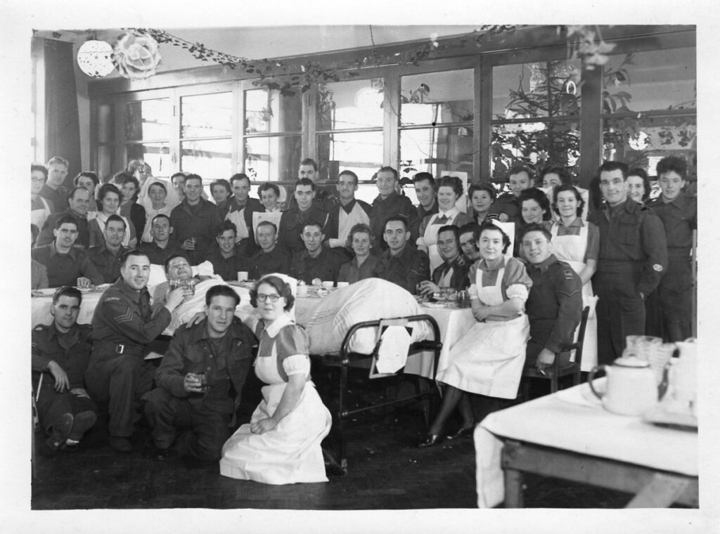
But the school had a short initial life. In 1941 the school was taken over by the Ministry of Health being administered as a convalescent facility by the Chesterfield Royal Hospital’s board of management. It was designed as additional accommodation for ‘war and blitz casualties’. The facility closed in 1945, at which time 5,143 patients had been dealt with, 1,815 being members of the forces. In early 1945 a rehabilitation and occupational therapy centre was established there both for in and outpatients. In September 1944 the Princess Royal (Princess Mary) visited, meeting 80 members of the forces, most of whom had been wounded in France. It was reported that only two of these were local men.
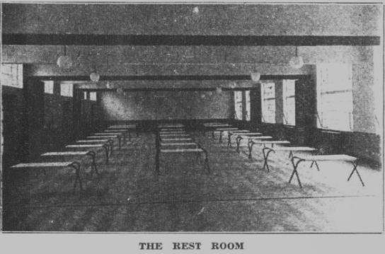
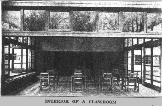
Extract from the 1938 large scale (25-inch to 1 mile) Ordnance Survey Map. The main house is the block to the left (the hatched structures are greenhouses). The rest room illustrated above is almost certainly the longer building to the top right, surrounded, in a semi-circle, by what must be the open-air classrooms. (Derbyshire sheet XXV.7 – Reproduced with the permission of the National Library of Scotland, National Library of Scotland – Map Images (nls.uk)).
The Ministry of Health required the hospital’s board of management to surrender Brambling House to the county education committee, presumably so that school activities could be resumed. Surrendering the property led to the hospital management board purchasing Ashgate House and grounds (later Ashgate Hospice) for use as a rehabilitation centre.
What became Brambling House Special School was later renamed Frank Merifield school in memory of its founding headmaster.
Here great emphasis was placed on access to fresh air, sunlight and physical activities. In 1950 is was reported that upwards of 150 children might be pupils there from nine months to three years, though some might be pupils for longer. A childrens’ centre was also based at Brambling house, which was designed to help pupils having difficulty at school. The establishment closed in 1988 as the approach to special needs education changed.
Another school
In 1997 the buildings were acquired by a private primary school, St Peter & St Paul, which had previously occupied outbuildings at Penmore House, but had its origin in Old Brampton. This school is still based at Brambling House. In 1965 part of the grounds were let (and later sold) to the Chesterfield & District Model Engineering Society, which developed an extensive and very popular miniature railway at Brambling House.
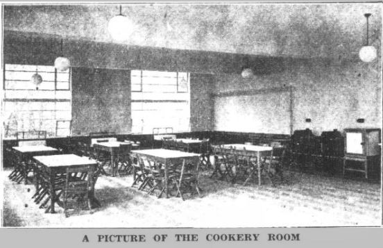
Finally a bit of a mystery. This photograph maybe of one of the converted classrooms at Brambling House in use as a convalescent facility for ‘warand blitz casualties’. The original owner of the photograph formerly worked at the facility during the Second World War and there is no other reason why she should have had the photograph. Compare the similarities with the ‘rest room’ photograph above, which is equipped with sliding partitions (like the one closed in the above photograph) and similar light fittings. Two things for sure is that you’ll not find this photograph in our forthcoming Hasland book and it’s Christmas!
This post was updated on 24 April 2022 to make it clear that Brambling House was in the former parish of Hasland and to add a link to an earlier blog on the boundary of Hasland parish.
History is never ending. What is today will soon become yesterday. In this rather picture heavy blog we look at what can only be called drastic changes in just one part of Bolsover town centre – at Sherwood Lodge and its grounds, once Bolsover District Council’s grand, but in parts short-lived, Civic Centre. It’s now the site of Morrison’s supermarket and homeware shop.
1) The much loved and much extended Sherwood Lodge – once the home of Bolsover District Council but now demolished and occupied by Morrison’s supermarket and other shops. The original building is to the left.
When we published our big red book’ on ‘Bolsover and adjoining parishes’ in 2013, we wrote that the former district council offices, based at Sherwood Lodge, just off the town centre, had been vacated a year after the council announced its intention to move in 2011. The scheme developed by the council would see its headquarters move to Clowne, with the former Civic Centre building demolished and replaced by a supermarket.
2) The Civic Centre pictured in January 2013 At this time the council had relocated to Clowne, but a small part of the building was being used by the police and as a council contact centre.3) It’s hard to believe it, but this is approximately the same view as 2 in March 2022.
4)Turning further to the right from our previous March 2022 view, Morrison’s new supermarket building has been built on the site of the far right building on our photograph 2.
The district council did, indeed, move and sold its former building, but not without much controversy. Some locals didn’t want to loose the original Victorian Sherwood Lodge buildings and the grounds, for example.
To make matters worse the supermarket scheme hit problems and the old Sherwood Lodge and its more modern extensions, the largest of which only dated from 1994, became increasingly derelict.
The 1994 building was constructed as a result of Bolsover District Council’s decision, in 1992, to vacate offices it had inherited from Blackwell Rural District Council at local government reorganisation in 1974. Perhaps bizarrely the old rural district offices were situated in Mansfield (presumably as most people in Blackwell would have travelled to that town). Prior to 1994 Bolsover District Council also operated from two premises in Bolsover and one at Shirebrook.
On opening in 1994, the Civic Centre in Bolsover, provided 5,442 sq ft of office space and a suite for members. New local offices were also provided, at the same time, in Clowne, Shirebrook, South Normanton, and Bolsover itself. But the new Civic Centre was to be short-lived.
The council offices scheme aside, Sherwood Lodge had an interesting history. It was built in 1897 for Abel Sykes who was a director of the Bolsover Colliery Company. In 1958 it became offices for the old Bolsover Urban District Council. In the 1950s its grounds were the centre of the ‘Bolsover Illuminations’, which we have previously written about.
Bolsover Urban District Council was itself established in late 1894, Like its predecessor (a local board) it met in the Portland Café in a designated ‘council room’. It moved to Ivan House in 1903, but in 1911 it acquired a former chapel in Cotton Street, moving to Sherwood Lodge in 1948. At this time the county library occupied the former Cotton Street offices. These were taken taken over by the Old Bolsover Town Council after the county council had built a new library in 1976. The town council still occupy these premises.
5) The impressive entrance to the now demolished Civic Centre, in January 2013.6) We think this is a similar view today, though such are the alterations in this area that it’s very difficult to exactly determine where things were.(March 2022).7) The Civic Centre was empty for some years, as the supermarket project failed to progress. It suffered serious vandalism. The former Sherwood Lodge building was the victim of an arson attack in November 2018.
Perhaps someday someone will write the fuller history of Sherwood Lodge, its grounds and the rise and fall of the Bolsover Civic Centre. Today, anyone visiting the area will be hard-pressed to see any remnants of the former occupant’s central role in Bolsover’s governance.